Tuesday, June 4, 2013

Bridges of Greenland Dock


There are four bridges of historical interest around the edges of Greenland Dock, only one of which is in its original position.  When the London Dockland Development Council decided to retain Greenland Dock, rather than filling it in, as had been done for most of the other docks, it was an obvious place to gather some of the original bridges.  The lattice bridge across the lock into Greenland Dock is in its original place; the others were brought in from other nearby areas to preserve them in an authentic environment.  They are all remarkably different from each other, and each is delightful.  A circuit of the dock makes a good short walk, and the bridges provide some really good landmarks and the views from  the lattice bridge are particularly good.


Lattice footbridge, Rope Street

Lattice footbridge


The lattice bridge (Stuart Rankin's name for it, which suits it well, given its similarity to lattice-truss construction bridges) was manufactured by Armstrong, Whitworth and Co. from bolted cast iron and has a walking surface of wooden planks.

It was constructed here in 1904 when the lock was extended to handle larger ships. It still crosses the lock of Greenland Dock, where it was originally located. Although the lock gates, the granite steps and the hydraulic gear have been preserved, the lock is now blocked off and vessels now enter and depart Greenland Dock via Steel Yard Cut, the linking channel between Greenland Dock and South Dock.  The bridge was renovated in 1987 and still looks good. It is Grade II listed.

A magnificent structure, the bridge is one of the best features of Greenland Dock.  It was not fixed in its position. Its two parts could be swung to each side when tall ships needed to pass through the lock.  It was operated by vast hydraulic jiggers, which are still preserved today, although it no longer functions.  The swing bridge was opened and closed by high pressure water through pistons in the cylinder equipment.  They are still in position in the pits next to the bridge on each side.


Steel Yard Cut Swing Bridge

Steel Yard Cut Swing Bridge
Moving clockwise around the dock, the next bridge of interest is another footbridge, Henry Grissell's 1862 swing bridge.  It now stands permanently open on either side of the above-mentioned Steel Yard Cut. 

Known as "Iron Henry" Grissell (1817-1883) started his working life as an apprentice to the Bramah iron casting and metal working company, before establishing his own business in the early 1840s.  The company, which Henry Grissell established with his brother Martin at the Regent's Canal Ironworks, built bridges for clients all over the world, and made the the gates and railings at Buckingham Palace and the British Museum.

Here's what Southwark's Planning Department has to say about the bridge:

Swing footbridge. 1862. Designed and manufactured by Henry Grissell (a renowned ironmaster). Relocated here in mid C20 from the Surrey entrance basin. A distinctive stayed cantilever design (unusual in metal bridges) with arched span in wrought-iron, stayed by iron rods to cast-iron counterweight. Hand operating gear remains, although an oil hydraulic mechanism added in 1980s.


Scherzer rolling bascule lift bridges

The Greenland Dock Scherzer rolling bascule lift bridge
Whatever sort of bridge was used to cross the Grand Surrey Canal is long gone, and the next bridge required to cross one of the connections between docks was that between Greenland Dock and Canada Dock (now Canada Water).  Today the old passageway between the two docks is a pedestrian underpass leading to Tesco with Salter Road passing over the top of it.  Parallel to the road, also bridging the underpass, is one of Rotherhithe's two remaining bascule bridges.

The bascule bridge at the end of Greenland Dock was originally at Deptford Creek (this photograph on the City of London Collage website appears to show it in action at its old location) and was moved here in 1959 to replace the wooden bridge that was here previously.  Its twin is still in situ in its original location at the Thames entrance to Surrey Water (next to the Old Salt Quay public house).

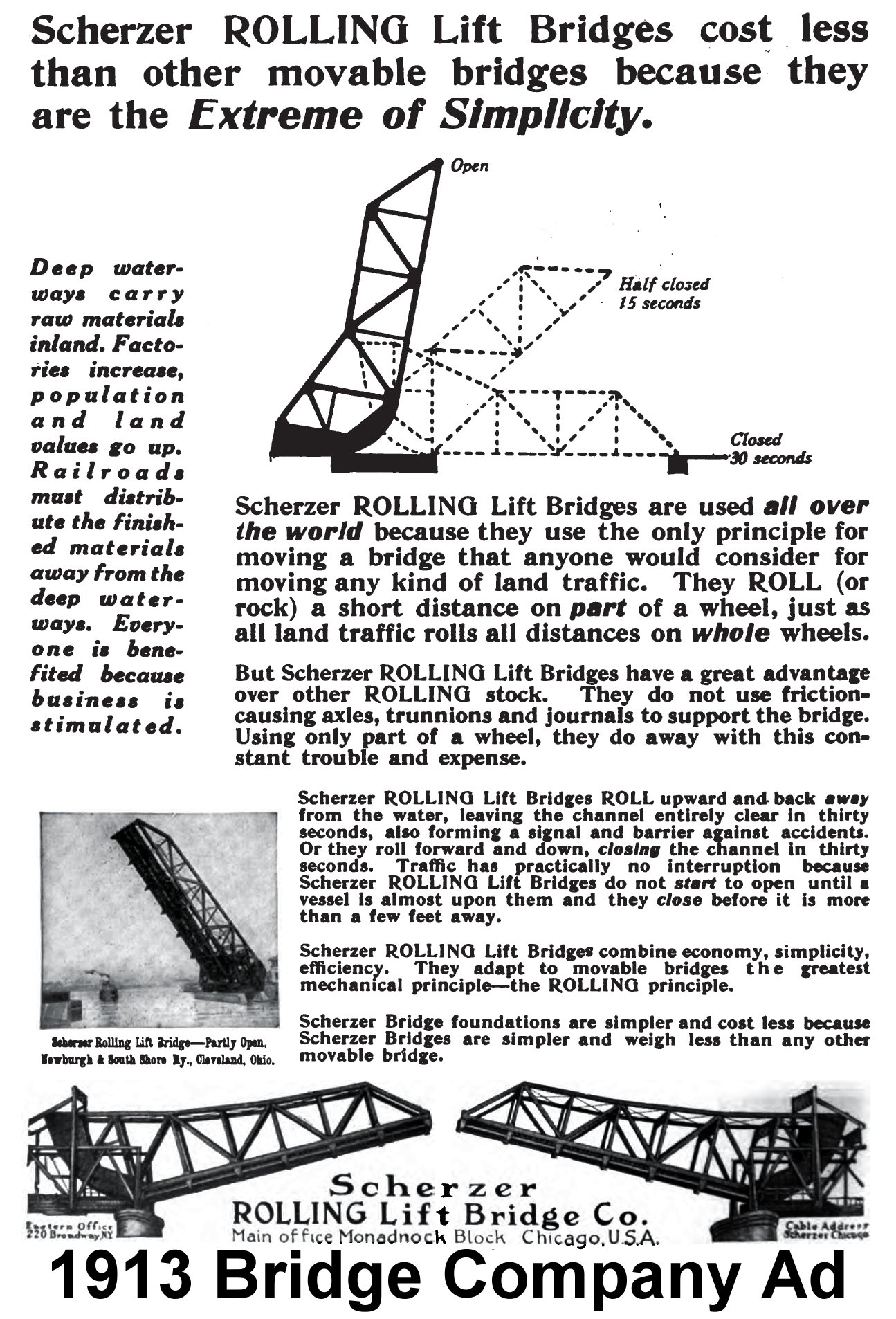
You have to love something that's called a "Scherzer rolling bascule lift bridge" even if you don't know what on Earth it means.  And it is a magnificent beast.   "Scherzer" refers to William Scherzer who pioneered a particular design of bascule bridges in the US.  The term "bascule" refers to bridges that open and close with a system of counterweights that balance the bridge continuously as the bridge rises and falls.  The whole bridge used to swing upwards on its rocker.  There's a lovely advert from 1913 on the Historic Bridges site showing how it operated: http://www.historicbridges.org/illinois/mcdonough/ad_large.jpg. Tower Bridge is a bascule bridge, but not of the Scherzer variety.


Norway Cut Swing Bridge 


Norway Cut Swing Bridge

Heading back around the dock towards the Thames once more, and passing the old inlet to Russia Dock and the Grand Surrey Canal, the final bridge on the circuit is the Norway Cut Swing Bridge.

It was designed by dock engineer James Walker in 1855 and was built by Walker, Burges & Cooper.  Its first home was at the lock entrance to South Dock. It was moved to the Norway Cut in 1987 and it, like the the other bridges around Greenland Dock, no longer moves.  It is set into two of its original granite plinths either side of the blocked off access channel (or "cut" or "cutting") to the former Norway Dock (now a development known as The Lakes).  Of you click to see the larger image, you can clearly see the gap int he middle of the bridge where the two halves meet.  It was manually powered, unlike many of the later bridges of the period, which were powered by hydraulics.  There is a round plaque providing a few details about the bridge.

James Walker by
Michael Rizzello
The bridge is now Grade II listed (English Heritage ID 471365).  Details of the listing are available at:  http://www.britishlistedbuildings.co.uk/en-471365-swing-bridge-over-cutting-between-greenl, which describes it as follows:

Wrought-iron plates and angles. Based on cast-iron precedents but owes its elegant lightness to use of wrought-iron with countersunk rivet heads, an early surviving example of riveted ironwork in bridges. Some welded steelwork discretely added in refurbishment. Original granite kerbs and paving reinstated at the new site.  

The English Heritage description also says that it is the second oldest bridge in Docklands, but somewhat frustratingly doesn't say which the oldest is!

A sculpture of James Walker is located near to the Moby Dick.


Rotherhithe in 1906.  Greenland Dock is the long dock
at the right of the image (with the shorter
South Dock at the far right).


As usual, my thanks to Stuart Rankin's excellent work for much of the information in this post (see the bibliography page).  The photographs are mine.


Views from Greenland Dock

Further to yesterday's wander round Greenland Dock with my new camera, here are a couple of snaps of the wider views.


Greenland Dock's Tavistock Tower
with The Shard in the distance


From the old lock entrance into Greenland Dock
looking over the Thames to Canary Wharf

Canary Wharf, from the marina at the Thames
end of Greenland Dock

Strata Tower at Elephant and Castle

Canary Wharf on the Isle of Dogs. Thank goodness for
the pointy top of 1 Canada Square, because without it
that particular skyline would be  a mass of squared-off
and very dull tower blocks.

Baltic Quay at South Dock (a truly innovative development,
which always stands out as something worth having in the area)
and, beyond it, the renovated but still-ugly Aragon Tower
on the edge of the Pepys Estate.

The new and deeply unappealing Barratt Homes
highrise, Ontario Point, at Canada Water

Monday, June 3, 2013

Views of Greenland Dock


I bought a new camera, which is powered by ordinary AA batteries, to supplement my giant Canon EOS digital SLR a few days ago, as something I can just chuck into my handbag when I don't want to take out the Canon. I took it out for a test run today for the first time.  It's a Fuji S4500, and even though I had seen one in a store a few weeks ago I was still taken aback by how lightweight and small it was when I opened the box.

 Having done a round of Greenland Dock with it, I find that I am absolutely not used to using anything either this tiny or weightless, and it is still odd to look through the rear screen rather than a viewfinder (although one of the reasons for buying this model is that it does offer a viewfinder as well).  It is going to take some time to become accustomed to not having all those heavy Canon optics in my hand.  But even on a first day of usage, using only the default automated settings without any attempt to manage the exposure, it hasn't done a bad job.

Here's the first set of views of Greenland Dock.  I'll post the second set, views from Greenland Dock, tomorrrow.


Coot, nest-making

Lock office on the right, with the Isle of Dogs
in the background

Henry Grissell's 1862 footbridge
in it's open position


Tavistock Tower flanked by The Shard and
the architecturally tedious Ontario Point

Cormorants on the Sailing School pontoon

Sadly neglected survivor from the
Surrey Commercial Docks

Greenland Dock

The Moby Dick

Greenland Dock towards the Isle of Dogs

Scherzer rolling bascule lift bridge

Trees lining the east side of Greenland Dock


Website: SE16.com

I stumbled across the SE16.com website a couple of days ago.  Definitely one to add to the list of useful local online resources.  The latest news is posted on the home page as an automated feed, but there are also News and Events sections, which provide archives of the most recent news stories under different categories.

Published by Bankside Press, a newsletter is sent out by email every Wednesday. They are also on Twitter at https://twitter.com/se16 and Facebook.

Bankside Press is a small family-run web and print publishing business based in London SE1.  Their main site is the eternally useful and very successful London SE1 Community Website http://www.london-se1.co.uk website has a very active discussion forum.


Friday, May 31, 2013

The Ebenezer Chapel and the Dockland Settlement Development


I have been trying to find out more about the development that is currently consuming the land that was formerly occupied by the Dockland Settlement, a considerably untidy community project that was a bit of an eyesore, but incorporated what was clearly once a rather nice chapel, the Ebenezer Chapel (a Norwegian place of worship and seamen mission), together with a contemporary two storey house, which was also obviously once very attractive.

It is all happening on the part of Rotherhithe Street that forks right off Salter Road, and is currently still marked on Google Maps as "Docklands Settlement Youth and Community Centre."  Southwark Council has this to say on the subject of the new development:

Planning application reference number 11-AP-2242
Proposal: Demolition of existing buildings, and erection of 28 residential dwellings (6x1 bed; 13x2 bed; 9x3 bed) within a part three, part four storey building at the southern end of the site with associated car parking, cycle storage and amenity spaces.  Erection of a new single storey community building (maximum height approximately 7 metres above ground) on the northern part of the site, accessed from Salter Road, providing general hall, meeting spaces and sports facilities, and a new flood-lit external sports pitch.

The Ebenezer Chapel and the attached house were recorded by archaeologists of the AOC Archaeology Group before it was demolished, and that 33 page report can be found here on the Archaeology Data Service website.:  "This was built in 1871 for the local Norwegian population. This building was recorded to Level 2 standard as defined by English Heritage Guidelines."  The photograph on this post is a screen-grab from that report, showing the Ebenezer Chapel, that stood at the site until recently.  There's a brief but good explanation of the background to the word Ebenezer (not a name, as I ignorantly thought, but from the Hebrew, meaning "stone of help") on the Missouri Conference website: http://www.moumethodist.org/news/detail/831 

If you're interested in the Scandinavian churches in Rotherhithe, there's an article on the subject from The Bridge available online at: http://www.southwark.anglican.org/thebridge/0912/0912p8.pdf.


Berkeley Homes planning new development near South Dock

There's a very short report on the Homes and Property website that gives details of one of the upcoming housing developments in Rotherhithe:  It's an extension of the existing Marine Wharf, to the east of South Dock, with 529 new flats built by Berkeley Homes.  I had a look around and more details are available on the Berkeley Homes website.  Both pages have artists' impressions.

Thursday, May 30, 2013

Views from Stave Hill


The views from the top of Rotherhithe's Stave Hill are always good. In the winter it is a lot easier to see the London Eye and Tower Bridge (you can just make them out at the far left and far right of the last of these photographs), but even with all the Spring foliage there are always buildings that stand out beyond the woodland - the new Strata Tower at Elephant and Castle (not shown in this set), 30 St Mary Axe (much better known as The Gherkin) and One Canada Square (Canary Wharf).  And now, The Shard is there on the panorama too.  The monstrosity to the immediate left of The Shard in the final photograph is, of course, Guy's Hospital, named for its founder Sir Thomas Guy (it was founded in 1721, so it can be considered some sort of success story, but one does wonder what Sir Thomas would make of it today!).

The building under construction near to the Gherkin in the first photograph is the new building at 122 Leadenhall by Richard Rogers, known locally as the Cheesegrater.  Although it wounds my soul to promote the Daily Mail, there's a rather good photo-story of the sky-scrapers popping up in the Gherkin/Cheesegrater area on the Mail Online website.


The Cheesegrater under construction and The Gherkin

The Shard

One Canada Square and the Isle of Dogs


One Canada Square

The Michael Rizzello sculpture at the
top of Stave Hill

The London Eye, far left, Guy's Hospital, The Shard and,
at far right, Tower Bridge


Wednesday, May 29, 2013

A walk in Russia Dock Woodland


At the weekend, on one of the few nice days we have had all year my father, who has been most unwell, thought that a stroll around the park might be a good idea, so we went out to enjoy the sunshine.  Russia Dock Woodland was lovely, full of wild flowers, bright green leaves and some really glossy yellow and cream roses.  On the big green families were enjoying picnics.

The recent work to revitalize the water supply to the ponds and channels has born fruit - I have never seen the water in the channels at this time of year before, and the Yellow Flag irises were clearly thriving on the conditions.  The good care given to the Woodland over the last few years really shows, and it was interesting to see the before-and-after photographs on the noticeboard by the green, which shows the real impact that the work has made.


Monday, May 27, 2013

The St Paul's Chapel (destroyed), Rotherhithe 1850 - 1955

Drawing copyright National Library of New Zealand
http://bit.ly/11e1KCB
The Anglican St Paul's Chapel, a chapel-of-ease to St Mary's Rotherhithe, was built in 1855 by  William Beatson and was badly damaged in the Second World War, perhaps destroyed.  There is some confusion about when it was finally demolished, but although it seems to have been decommissioned in 1955 records indicate that some part of it was in use on the site until the 1970s. 

St Paul's was located at Ram Alley, later Beatson Street, close to Surrey Canal School which later became St Pauls School (TQ360804). Today it is the site of Peter Hills with St Mary and St Paul School. William Beatson's descendents live in New Zealand and the plans of the church are registered with the National Library of New Zealand (rightt). 

Some lovely water-colour diagrams of the Chapel can be found on the National Library of New Zealand website at: http://bit.ly/12bFuhu

In the 1912 "A History of the County of Surrey: Volume 4" it is described as follows:
The church of ST. PAUL in Beatson Street, a chapel of ease to the parish church, consists of a chancel, nave of five bays, north vestry and south porch. It is built of yellow stock brick with stone detail, and is designed in 13th-century style with an effectively high-pitched slated roof and small lancet windows. It was built in 1850. There is an ample churchyard now used as a small park. (http://www.british-history.ac.uk/report.aspx?compid=43036) 

The architect, William Beatson, was a member of the successful shipbuilding company and family business John Beatson, and had shipbuilding interests in his own right.  He sketched the tragic mastless remains of the Temeraire (immortalized in Turner's "Fighting Temeraire") as she sat in Rotherhithe waiting to be broken up by the John Beatson yeard in 1838 (the sketch can be seen on one of my earlier posts here: http://russiadock.blogspot.co.uk/2009/11/rotherhithe-heritage-9-1825-1843.html). And in fact, the chapel was renovated in the late 1800s using timbers salvaged from the HMS Temeraire.


Saturday, May 25, 2013

Bermondsey Yesterday and Today


I've found another local website that appeals to me considerably: Bermondsey Boy.  There are various aspects so the site, but the bit that I particularly like is a section "Bermondsey Yesterday and Today" that compares photographs of Bermondsey in the past, with photographs taken in the same place, often from the same angle, today.

Here's a good example from Rotherhithe's Canon Beck Road (at http://www.bermondseyboy.net/2010/08/16/bermondsey-yesterday-and-today/#post14) but do have a look at the rest of the section.  There are dozens of then-and-now photographs to look through, and they are truly fascinating.  A good use of the Google Maps "Street View" feature.  I love the glimpse of a ship over the wall at the end of the road in the earlier photo. So sad that the lovely block of solid housing was demolished to be replaced by one of the low cost but fashionable architectural schemes that characterize parts of Rotherhithe.  Not that they are unattractive, but their predecessors were really quite lovely in many ways.


The future of the Surrey Docks Health Centre

At a rare visit to the Surrey Dock Health Centre during the week, the following information was being stuck to the walls.  This might be of interest for anyone who is registered with the surgery and wants to know what the future holds for it now that the new Downtown development by Barratts is in full swing.  As people concerned with the development will probably already know, provision was made in the planning submission for the existing health centre to be demolished and replaced with a new one that will be incorporated into the Barratts development.

Patient Participation Group

Join us for our Annual General Meeting
Everyone Welcome!
Wednesday 12th June 6.30pm

Information Evening

• Find out more about the New Health Centre from Barrett's
• Find out about what the PPG do
• Informal evening with wine and nibbles
• A chance to meet other patients and members of the practice team

You can find out details from the Surrey Docks Health Centre website at:
http://www.surreydockshc.co.uk/

The existing health centre, which looked terribly unloved and run down even before Barratts started tearing down trees and bulldozing the site, must have been quite an avant garde structure for a health centre development in its day, with its central courtyard garden, the tall, steeply slanted roof providing natural light for the waiting room and the surrounding outdoor seating areas under the trees.  Never a thing of beauty, it did have some very real virtues and it is a shame that it should have become so very downtrodden.


Northern end of the Rotherhithe Tunnel in 1925

http://www.portcities.org.uk/london/server/show/conPopUp.104/noClose/1/Rotherhithe-Tunnel.html


The Rotherhithe Tunnel was the second of the London County Council's road tunnels. It linked Rotherhithe with Shadwell on the north bank. Designed by Sir Maurice Fitzmaurice, it was begun in 1904 and opened in 1908.

More on the above page.


Wednesday, May 22, 2013

Saye's Court - London's Lost Garden

http://londonslostgarden.wordpress.com/

Thanks to the Transpontine blog for this link to The Saye's Court - London Lost Garden  blog, which I hadn't seen before.

Saye's Court was one of the homes of diarist John Evelyn (1620-1706), which came to him through his wife's family on his marriage to her.  Strictly speaking, it's outside the scope of this Rotherhithe-based blog, because Sayes Court was down the road, part way to Deptford, in the immediate vicinity of the former Royal Docks.  But Evelyn's diaries are favourite reading of mine, shedding light on the area as a whole during the period when he lived here. Evelyn was a keen botanist and the Sayes Court gardens were full of plants that he had gathered from far and wide across the planet.  Sayes Court was so conveniently located for the docks that Peter The Great rented the house and its gardens when he came to learn the art of ship building (John Evelyn's accounts about the damage inflicted upon the property by Peter and his retinue make for some splendid reading). 

The London's Lost Garden blog began in February 2010.  I've spent a happy hour reading through previous posts. Here's an excerpt from the first post, which I really liked.

It was one day early in  2005, soon after we’d moved into our flat nearby, that we first discovered Sayes Court Park, adjacent to the currently-disused Thames-side dockyard in Deptford.  I was interested in seeing the wizened mulberry tree at its heart, supposedly planted some three hundred years ago by Czar Peter of Russia, of all people.

Old mulberry tree in Sayes Court Park

I was a bit sceptical of that particular legend even then, and am more so now that I have read the contemporary accounts of Peter’s behaviour during his visit. But I was nonetheless intrigued by the idea of a tree surviving from the greener, pre-industrial landscape in these parts. The gnarled but still vigorous and reportedly fruitful mulberry at least held out the eventual prospect of a taste you can’t buy at Tesco.

 If you ask local people about the park, some will tell you that John Evelyn, a friend of Samuel Pepys, and like him a diarist,  had a famous garden there. His house, and the garden, were indeed called Sayes Court.   The question was, how much, if anything, remained from Evelyn’s day in the modern park?

 Once you’ve got your eye in for it – by archaeological fieldwork, surveying, studying old maps – you develop an almost tangible sense of the past under your feet. 

Tuesday, May 21, 2013

A civic society or urban parish council for Rotherhithe?

http://www.se16.com/1132-a-civic-society-or-urban-parish-council-for-rotherhithe

Time and Talents has been asked by the Bermondsey and Rotherhithe Community Council to investigate the interest in setting up a civic society or urban parish council for Rotherhithe.  For the purpose of this activity  Rotherhithe is defined according to the historic boundaries of St Mary’s parish, bounded by Southwark Park Road in the west, the river to the north and east and South Dock in the south.

See the above page for more, and to fill in the online survey.

A meeting will be held on 30th May to discuss the results of the survey.


Friday, May 17, 2013

Rotherhtihe Street Names - part 2

Again, just for fun, here is the second part of a look at how the streets in Rotherhithe gained their names. 
Part 1 can be found here:
http://russiadock.blogspot.co.uk/2009/04/rotherhithe-street-names-part-1.html
Part 3 is here:
http://russiadock.blogspot.co.uk/2013/10/rotherhithe-street-names-part-3.html


From Linney 1929
Acorn Walk
Named for the Acorn Pond, which was itself name for a pub that no longer stands.  The Acorn Pond was located where the modern housing development was built at Downtown, incorporating the Surrey Docks Medical Centre.  Its purpose was to float the timber imported from Canada and the Balkans.

Brunswick Quay
When Greenland Dock was extended at the end of the Nineteenth Century it absorbed a yard called the Lower Brunswick Yard. The houses and road that make up Brunswick Quay were built over the edges of the yard, which is marked on the 1896 map of Rotherhithe.  New Brunswick in Canada was one of the many sources of the timber that was processed and stored in the Rotherhithe docks, ponds and yards.

Deal Porters Way
The deal porters were the highly skilled handlers of deal - planks of softwood. Many eventually wore leather hoods with tails which were wrapped over the shoulder for protection. Stacking the planks in piles up to 60ft high was highly skilled. The deal porters worked the Surrey Commercial Docks throughout the early and mid 1900s, a job which was passed down from father to son.

Lady Dock, centre right, in 1921
Lady Dock Path
If you ever catch the 381 bus you'll be accustomed to hearing the stop being spoken by the recorded voice "Lady Dock Path, the Ship York." Lady Dock Path was named for Lady Dock, which is shown on the 1894 map of Rotherhithe, and was connected to the Thames first through Norway Dock, which opened into Greenland Dock, which had lock access to the Thames.  In spite of its name, the current path runs through the site of the old Norway Yard,which ran along the east side of Norway Dock, 

Moodkee St
Although I cannot find out what, if any, the local connection may have been, Moodkee refers to a famous battle that took place in the Punjab area of northweast India.  The first battle in the First Sikh War, the Battle of Moodkee took place on 18th December 1845.  Indian and British troops formed a joint force against the Presidency of Bengal's Punjab army, the Sikhs of the Khalsa.  The battle was named for the Punjab town of Moodkee (which can also be spelled Mudki). For more about the battle see http://www.britishbattles.com/first-sikh-war/moodkee.htm. 

Elephant Lane
I have been unable to find out why this street was so-named.  The obvious supposition was that there had been a public house of the name, but I can't find any record of one, so I wonder if it wasn't something to do with the above-mentioned Battle of Moodkee.  As part of the preparation for the battle, stores were moved to the Punjab using three hundred camels and sixty elephants. It seems a bit of an unreasonable stretch, even though the two roads are close to each other, so if anyone has a better answer, do let me know!

Odessa Street
In the early Nineteenth Century Odessa was an important Russian port on the Black Sea, exporting grain and flour.  Some of that grain was brought into Rotherhithe docks, including South Dock, and wharves, including Odessa Wharf.  The Odessa Wharf building, near the Ship and Whale public house, is one of the oldest surviving in Rotherhithe, dating to 1810, and was used for the storage of grain imports.  The original brick-built warehouse has now been converted to apartments, and runs along the side of Randall Rents, a right of way that predates it. 

Onega Gate
Named for Onega Yard, which is marked on the Ordnance Survey 1894-96 map. It was located just north of Norway Dock and immediately fronted Commercial Dock Road, part of which is now Redriff Road. It began at the inlet from Norway Dock into Lady Dock where a swingbridge crossed the cut. It extended the full length of Norway Dock to the east of the bridge where a set of large buildings ran across the end of Norway Dock.  Onega was a Russian coastal town, where English industrialists were granted rights to fell timber and set up sawmills for export to English processing depots. The Onega Yard in Rotherhithe was one such timber import yard.

Randall's Rents
Randall's Rents is a slender alley leading up towards the Thames, along the side of the 1810 Odessa Wharf building, one of the oldest remaining buildings in Rotherhithe. Randall's Rents is the only remaining survivor of a whole network of similar passages which connected the dockers' homes with their dockland workplaces. It was originally named Wet Dock Lane when it was laid out by local shipwright John Wells in 1698. The name was changed to commemorate the local shipyard owner, John Randall, who owned houses that he rented to the workers at his yard. The shipyard built many beautiful ships for the Royal Navy, including the HMS Ganges and the HMS Culloden in 1779 and the  HMS Serapis in 1799.  I would love to see what it looked like in those days. 

Ropemaker Road
Rope making was an essential part of ship building activities in the 15th, 16th, 17th and 18th Centuries.  The bigger the ship, the more rope was required for rigging. Warships and tea clippers were major consumers of rope.  The longer the rope required, the longer the rope-making premises (rope walk) required.  There were various rope walks in the area.  By 1843, the nearest rope walks to Rotherhithe were along the Bermondsey Wall, roughly half way between the Angel public house and St Saviour's Dock. A functional rope walk is still visible in London's Chatham dockyards, which is a quarter of a mile long.  See more about the Chatham rope walk,with photos at http://www.thedockyard.co.uk/NetsiteCMS/pageid/740/About_the_Ropery/explore_ropery.html/About_the_Ropery/explore_ropery.html.

St Paul's Avenue
This road, opposite Globe Wharf, is named for the Nineteenth Century church of St Paul that used to be located here.

Quebec Way
Quebec was one of a number of sources of wood, which was processed and stored in the timber ponds and yards in Rotherhithe.  The 1896 map of Rotherhithe shows a Quebec Pond together with the Quebec Upper and Lower Yards. It is also shown on the 1921 map, above.  The yards ran the length of Russia Dock (now Russia Dock Woodland) on its western side. In the Second World War, on the first day of the London Blitz, the Quebec Yards were bombed by the Luftwaffe. At that time a store for deal timber, the yards burned in an immense fire.  The modern Quebec Way crosses the former site of the pond, where the printing works are also sited.


Tuesday, May 14, 2013

Dockland and maritime phrases that have survived into colloquial English

Just for fun, here are a few dockland and maritime idioms and phrases that have survived into modern colloquial English.
HMS Victory in 2008.
Photo by Andrea Byrnes

First-rate, second-rate and third-rate

Today if we call something first rate we mean that it is at the top of its class, something really rather special, whereas something third rate is really rather poor.  Originally, these were terms associated with different types of Royal Navy ships of the line that were built in the 16th century at the Deptford Royal Docks, Rotherhithe and elsewhere in Britain.  First-rate ships, which had three decks and around 100 canons, were almost prohibitively expensive to build and maintain, and only a few were in service at any one time.  The HMS Victory, which in preserved in Portsmouth, is the only surviving First-rate ship of the line.   First-rate ships were only built at the Royal docks but third-rate ships could be built at lesser shipyards, including some of those around Rotherhithe.  Each class of ship had its own benefits and a third-rate was not considered to be inferior to a first-rate, so the modern usage of the term has altered the original sense of the rating system.

Toe-rag
Nick name given to grain porters in the docks and convicts in the early 1900s. They wrapped the sacking rags around feet and legs to protect themselves against the sharp grain residues. It has passed into the modern vernacular as a somewhat insulting term applied to individuals who are considered to be generally useless or unpleasant.

Dutch Courage
Free Trade Wharf. Photograph by Adrian Pingston
(Public Domain)
Taking a boat ride from Greenwich to St Katharine's Dock I listened to the crew's commentary, which said that the term Dutch Courage (now used to indicate bravery derived from the consumption of alcohol) actually dates to the Great Plague of London in 1665. The City of London was sealed off to prevent the spread of the plague, which effectively cut it off from any food supply. The story was that the only traders brave enough to approach London were the Dutch, who left food on jetties in return for money that was left there for them. The reference to alcohol comes from the story that the Dutch would drink liquor before entering the area, to bolster their courage The Dutch were granted the freedom of the river Thames in return for this life-saving service. According to the boat's guide, they used to travel down the Thames as far as the wharf now located by the brown "lego" building called Free Trade Wharf. I've never actually found a documentary confirmation for this, but it's a good story! Most of the explanations available for Dutch courage refer to a type of gin developed by the Dutch and consumed by troops during the Thirty Years War.

Money for old rope
Rope which had deteriorated to the point where it could no longer be used as rope was sold to prisons and workhouses where it was dismantled into its original fibres. This product was known as "oakum" and was used to seal the gaps in ship decks. The payment for the redundant rope became known as "money for old rope".

Flotsam and Jetsam
Two separate terms for things that were found floating on the sea or river surface in the 16th and 17th Centuries.  Today, the words are used together to indicate that something (or someone) is worthless.  In the past, flotsam referred to items that were released by the action of the sea itself or were accidentally released into the water (like the remains of a sunken ship), and jetsam referred to items that were deliberately thrown overboard from ships. 


Sunday, May 12, 2013

Thames Circular Walk

http://thamesfacingeast.com/2013/04/01/thames-circular-walk-no-1/

St Mary's, Rotherhithe
This looks like a really good circular walk on the Thames Facing East blog, taking in both north and south banks of the river by using the Hilton Hotel's ferry and Tower Bridge.

On the Rotherhithe side it includes the Angel public house, the foundations of Edward III's manor house, the Brunel engine house, the Prince Boo memorial, Rotherhithe village, the Mayflower, before walking to teh Hilton and crossing over the Thames on the ferry to resume the walk.

The walk then proceeds along the Thames Path to Limehouse and Tower Bridge.  It looks like a great walk.  The post has photographs of some of the sites to be seen along the way.


Saturday, May 11, 2013

How the Shard is ushering in Rotherhithe’s next wave of development

The Shard. Photograph by
Ben Griffin, via Wikimedia.
http://pastinthepresent.net/2013/04/10/how-the-shard-is-ushering-in-rotherhithes-next-wave-of-development/

This article kicks off with several paragraphs about Rotherhithe's fascinating history before going on to look at Rotherhithe today and development plans for Surrey Quays shopping centre and the Daily Mail's Harmsworth Quays,

It also suggests that the Shard will see much of these new developments being populated by occupants of the Shard:

Walking around Rotherhithe today, it seems as if it’s about to take yet another leap forward. Just 10 minutes from the Shard, where 10,000 people will eventually work, you can see why property developers are getting enthusiastic about snapping up the few parcels of land that remain.


Thursday, May 9, 2013

Willow Warblers and more in Rotherhithe

http://rothandb.blogspot.co.uk/2013/04/willow-warblers-and-more-in-rotherhithe.html

From the Rotherhithe and Beyond blog, with some lovely photos:

I spent a couple of pleasant hours locally in Rotherhithe this evening. And with the weekend of birding promise ahead, I was in a relaxed mood. So much so that I actually stood for several minutes, just listening to one of the Willow Warblers that currently occupy Russia Dock Woodland. Willow Warblers are just a passage migrant in Central London, so I only really hear the melancholy song for a few days each year.

Walking Rotherhithe Tunnel

http://carolineld.blogspot.co.uk/2013/05/walking-rotherhithe-tunnel.html

Another great post, with photos, on Caroline's Miscellany. 

While Greenwich and Woolwich have pedestrian foot tunnels, nearby Rotherhithe is generally thought of as a tunnel for motorists. In fact, there is pedestrian access as well, with a pavement provided on each side of the roadway. In the interests of tunnel completeness, I decided to take a walk inside.


Thursday, October 4, 2012

Tide, time and talents, Rotherhithe

http://carolineld.blogspot.co.uk/2012/10/tide-time-and-talents.html

Caroline has posted on her excellent blog, "Caroline's Miscellany," about Rotherhithe's Old Mortuary. With some excellent photos.

 There was a double dose of Victorian history at one Open House property in Rotherhithe. The Old Mortuary, now the home of Time and Talent, is unassuming but has a great deal of interest.

First, the mortuary was built in 1895 to deal with bodies found in the Thames. Many washed up in Rotherhithe, and fees were paid to the finder - with more money if an inquest was held, and perhaps a reward from the family of the deceased. One factor for the finder to consider was just how much the retrieval was worth; Rotherhithe paid more than some neighbouring areas such as Deptford. There was therefore a steady supply of bodies arriving here from the river.

Tuesday, September 25, 2012

Magical Mystery Tour in Rotherhithe

http://thescribblaire.wordpress.com/2012/09/23/magical-mystery-tour/

A nice account by blogger "the Scribblaire" of a walking tour of Rotherhithe, with photographs.

It was a beautiful Autumn day in London yesterday, with watery sunshine and a slight chill in the air.  A perfect day for walking.  The Scribblaire’s other half had arranged for a trip to somewhere in London that we had never visited.   I had thought that it might be to a church in The City that he had discovered recently, but I was wrong.

We boarded the train to Waterloo station and, on arrival, headed for the eastbound Jubilee line.  Once above ground at Canada Water I was shown a sign pointing to the Brunel Museum and told that this was our destination. 

Tuesday, September 18, 2012

RM22/78 Rotherhithe (map) Bomb Damage

A fascinating map of the Surrey Commercial Docks on Yersinia's Flickr site, which was picked up by Google Alerts. Click to see the bigger image.  The link no longer works, sadly, but the map is still interesting.


Key (provided by Yersinia):
Black - Total destruction
Purple - Damage beyond repair
Dark Red - Seriously damaged, doubtful if repairable
Light Red - Seriously damaged, repairable at cost
Orange - General blast damage, minor in nature
Yellow - Blast damage, minor in nature
Green - Clearance areas
Small circle - V2 Bomb
Large circle - V1 bomb

Squat Property - Rotherhithe 1983

The Times Live, za (Ben Trovato)

A fascinating if somewhat bleak and disturbing look into another way of life in Rotherhithe 20 years ago. Unfortunately the link is now dead, and I've been unable to find a copy anywhere else.  So this is a snapshot of an article that appeared on The Times Live, ZA.  It was an interesting enough snapshot of Rotherhithe before the LDDC redevelopment of the area to be worth publishing here, even as a fragment.

The author, Ben Trovato, used to live in a squat in Rotherhithe and paints a portrait of what the area was like back then. He then went on to make some interesting observations on what he found in Rotherhithe today.

We’ve already picked out a ground-floor flat. Sticking to the shadows, we reach the door and go to work on the lock. It takes three minutes for the hacksaw blade to snap. The crowbar is no help. Nor are the screwdrivers. This leaves the sledge hammer. I pick it up with both hands and am about to deliver a death blow when a police siren cuts through the fog. We grab the tools and make it to the stairwell just as a sleek, white Rover veers into the estate. Cops pile out of it and begin searching an area 50m from us. They leave. We exhale. Ten minutes later, the lock shatters and the artist uses his Doc Marten boot to open the door. We replace the lock and become the legal occupants. Vote Labour.
It seems too good to be true. A clean three-bedroom flat with a view of the Thames for which no rent will ever be paid or demanded. Sure, there is no electricity, gas or hot water, but we can’t exactly complain to the council. After weeks of living by candlelight, which doubles as our central heating, we meet a gentleman who shows us how to bypass the meter for the price of a bottle of rum.
Rotherhithe is a rough area, no doubt about it. There are half a dozen heroin dealers living within a five minute walk of one another. Some squatters have their cars set alight at night. Punks, skinheads and anarchists share an uneasy existence alongside angry, rent-paying Cockneys. These legitimate tenants hate us for living in flats identical to theirs, but for free. I come home one night to find “Squatters Will Die” spray- painted across the door.

The Rotherhithe of Geoff Howard

http://thelondoncolumn.com/2012/09/03/rotherhithe-photo-text-geoff-howard-15-2/

From the forward to Rotherhithe Photographs, 1971-80 by Geoff Howard:
Ship and Whale, Rotherhithe.
© Geoff Howard 1975
Rotherhithe was a riverside village to the east of London in medieval times, but the real development of the area started with the major dock building in the first half of the 19th century; these docks were amalgamated into the Surrey Commercial Docks in 1864. Surrey Docks are only a part of Rotherhithe, but people tended to use the two names almost interchangeably. Surrey Docks underground station is at the south end of the docks; Rotherhithe Street itself follows the bend of the river Thames around the north side of the docks. Rotherhithe Street – the longest street on London – or was it in England – bordered by high walls hiding the docks, with just occasional gaps at a gate or bridge, with glimpses of water or warehouses, and like all the surrounding streets mostly deserted, a ghostly, uninhabited feeling, broken by small estates of council flats, a few pubs, some newsagents or little corner shops. The river on the other side of the road, often just a few steps down to the water.

While these photographs date from 1971 to 1980, the majority were taken between 1973 and 1975. It was the time after the closure of the docks in 1969 but before the complete redevelopment of the whole London docklands area, north and south of the river Thames, during the 1980s.


Great London history blog: HistoryLondon


A blog by Julian Woodford ("Transmitting gobbets of London's past for the edification of the world," whose book The Boss of Bethnal Green: Joseph Merceron, Godfather of Regency London will be published soon. I've been following it on Twitter: @HistoryLondon.


Saturday, September 8, 2012

London Blitz, day 1, September 7th 1940

The Guardian

From The Guardian website, above:
Using Google Fusion tables, we've produced this map of the first day's bombing. Click on a red dot to get details -once it's loaded

Wednesday, June 13, 2012

The Great British Story - A history of Greenland Dock

BBC News

Brilliant short video about the history of Greenland Dock

The Great British Story looks at how London's Docklands have been transformed over several centuries of history.

Presenter Peter Snow talks to historian Fiona Rule about how Greenland Dock on the east side of the Rotherhithe peninsula was transformed in the late 17th Century.

The dock was a monumental achievement for its time and developed as a centre for the whaling trade.

It became an early template for London's super-sized docklands that spread across east London in the 19th Century.

The Great British Story - London's Docklands is broadcast on Tuesday, 12 June on BBC One London at 22:35 GMT and nationwide on the iPlayer thereafter.

The whole episode (dealing with all of London's Docklands) can be seen on BBC iPlayer (and is well worth watching if you have iPlayer, which you can load free of charge):
http://www.bbc.co.uk/iplayer/episode/b01jxrhv/The_Great_British_Story_Regional_Histories_Londons_Docklands/