Showing posts with label WW2. Show all posts

Sunday, December 6, 2015

Mulberry Harbours at Rotherhithe's South Dock in the Second World War

During the Second World War South Dock's lock was badly damaged and could no longer be used for access from the Thames.  As a strategic commercial target the docks had been targeted by German bombers and this was only one of many dock structures to be devastated.  South Dock and Greenland Dock had independent lock entrances because they had been owned by separate dock companies, but when the two docks became part of the same company a cut was created to link the two, so access to South Dock was still possible via the Greenland Dock lock entrance.  However, in 1944 there was a pressing need for dry docks for the construction of Mulberry Harbours, so the decision was made to cut off South Dock from Greenland Dock, to ready it for the construction of concrete sections of Mulberry units for the armed forces. 
Schematic of main components of the
Arromanches Mulberry Harbour, from the
Combined Operations Command website


So what were Mulberry Harbours and why were they so important?  "Mulberries" were designed to meet a logistical problem to an assault on the Normandy beaches that would make a profound difference to the outcome of the war.  In 1942 the British attacked the heavily fortified town of Dieppe and were turned back.  But if British troops were to be landed in France, some part of the French coast would have to be breached, and it was decided that the beaches of Normandy would be the best option.  But there were two problems.  First, any invasion would require huge numbers of men and heavy equipment, and with no infrastructure in place to receive, unload, process and supply the  invasion, and the difficulties inherent in capturing a suitable port posted a potentially massive problem.  Second, troops and supplies were to be landed directly on the beaches but the coastline of Normandy featured long and shallow inclines, meaning that at low tide boats could not approach near enough to the shore to offload their cargoes.  But these was the sort of problems that the armed forces were expert at solving. Churchill had had a similar idea in 1917 to cope with the capture of two islands in the Danish-Dutch seas, but the man usually credited with the idea of the Mulberry Harbours is Hugh Iorys Hughes whose brother Commodore John Hughes-Hallet presented it to the Navy.  Whoever it was who came up with the idea, it was concluded that if a harbour could not be captured, then a harbour should be built, transported and then installed wherever it was needed.  These were the Mulberry Harbours. 


Surviving Phoenix caisson breakwater components
at Arromanches.  Sourced from Wikipedia
Mulberry Harbours were modular units which, when assembled, could be used to create temporary harbours along the Normandy coast.   They consisted of pier-heads (known as "spud-pontoons"), piers ("whales"), inter-linked concrete pontoons "beetles"), caissons to form breakwaters ("phoenixes") and in-shore shelters provided by ships forming a barrier (gooseberries).  There is a brilliant description of how all these elements fit together on Chris Bridges's "Mulberries and Gooseberries" page, together with some super illustrations.  Floating pontoons were placed at 80ft intervals between the pier-head (where boats would dock) and the beach and carried the 80ft-long piers (whales) that formed floating roads that allowed people and cargo to be unloaded onto the shore.  As the tide raised and fell, so too did the floating moorings, allowing ships to moor and offload, even at low tide. 146 caissons were required to form 9.5kms of breakwater to protect both the piers and the ships, each 60 metres long, 18 metres high and 15 metres wide.  The breakwaters formed by Phoenix units, more or less parallel to the piers, and the sheltering barrier of ships called gooseberries formed protecting arms to emulate a true harbour.

 
Diagram showing how the piers were deployed at high and low tides. From
Chris Bridges. Mulberries and Goodberries. http://www.hksw.org/despatches_107_1_a.htm


After various experimental prototypes were tested, two Mulberries were assembled for deployment:  Mulberry A at Omaha beach, and Mulberry B at Arromanches, each with an intended capacity of  7000 tons of vehicles and supplies a day. 

Artist's impression of a Phoenix caisson, showing hw
they were shaped to resemble lighters.
From the war44.com website
Different parts of the Mulberry Harbours were manufactured in different places (much as the Airbus is today), transported to a distribution hub and were later assembled where they were needed.  This was because of the sheer amount of work involved, described evocatively on the Combined Operations Command website"The scale of the project was enormous and was in danger of over-stretching the capacity of the UK's civil engineering industry. From late summer of 1943 onwards three hundred firms were recruited from around the country employing 40,000 to 45,000 personnel at the peak. Men from trades and backgrounds not associated with the construction industry were drafted in and given crash courses appropriate to their work. Their task was to construct 212 caissons ranging from 1672 tons to 6044 tons, 23 pier-heads and 10 miles of floating roadway."   

Phoenix' concrete caissons, part of the Mulberry artificial harbour,
being constructed in Surrey Docks in Rotherhithe, London,
17 April 1944. Imperial War Museum H37607
The component that was manufactured at South Dock was the caisson, or Phoenix, used to form the breakwaters.  The contract for building twelve Phoenix B sections in Rotherhithe was given to John Mowlem, a civil engineering company, in late 1943.   The Phoenix units  were airtight cases made of concrete and steel that were open at the bottom. Although they look fairly boxy, they were shaped at bow and stern ends to resemble barges on the grounds that they would have to be sea-worthy both when being towed and when in position. They were designed to float and were fitted with air-cocks so that they could be lowered evenly to rest on the sea-bed.   Eight were to be built at South Dock, four at Russia Dock (also on Rotherhithe) as well as another six at East India Dock on the north of the Thames.  South Dock was turned into a dry dock by Mowlems, who drained the dock, sealing it with a concrete barrier at the lock and blocking the cut that connected South Dock to Greenland Dock.   The base of the dock was then covered with 6ft of rubble to ready it for the construction of concrete sections of the Mulberry units.  South Dock must have been a strange sight with no water in it.  The above photograph from the Imperial War Museum shows what the units looked like when under construction at South Dock.  It is a truly spectacular scene!  The photo has been taken the eastern edge of Rotherhithe, looking over the Phoenix units towards Greenland Dock, which is still filled with water and has a ship in dock.  The sheer number of cranes that serviced both docks is impressive - many of the crane tracks still exist but there's nothing like seeing a photograph of what it was all like in action.

Surviving Phoenix units at Portland Harbour
On the 17th March 1944 the Phoenix sections under construction at South Dock had all been completed. Steelyard Cut, which still links South Dock with Greenland Dock, was re-opened, the dock was refilled via Greenland Dock, and the Phoenix sections were floated out first through the cut, with only 9 inches of clearance and then out onto the Thames through Greenland Dock's entrance lock, and transported downriver and out to British coastal destinations.  Each was fitted for the journey with a small crew, a temporary cabin and an anti-aircraft gun, which came into use when a German bomber flew low to take a closer look and was fired upon.   Many of the caissons were initially sunk to hide them from German spy planes, and were re-floated, with some difficulty, when ready for deployment in France.  


Mulberry Harbour B.  Photograph from Mulberries and Goosberries by Chris Bridges.


Main Sources:

My brief article has looked at Mulberry Harbours through a Rotherhithe-centric lens, and the main sources for the post are listed here, but if you are interested in Mulberry Harbours and want to find out more, there is a lot more information about them all over the web, and of course in some excellent books about the Second World War. 

And a HUGE thank-you to Michele of the What's On In Rotherhithe Group (http://www.se16-worg.co.uk) for pointing me to the photograph of Phoenix units being built in South Dock.


Thursday, March 5, 2015

Book: "On The River: Memories of a Working River"

Enormous thanks to Alfie Read for lending this book to me.  It was he who loaned me Between Bridgers, and has plenty of terrific stories of his own.  On The River was published in 1989, on the centenary of the Dockers' Tanner Strike of 1889.  It covers all of the docks and the main channel of the river.  Fascinatingly it began as a piece of Reminiscence Theatre that used the words of the contributors and the songs they remembered to assemble a touring show. 

It begins with  a short Preface by Pam Schweitzer, one of the book's editors, and an Introduction by Ron Todd, the then General Secreatary of the Transport and General Workers' Union.  These are followed by some reflection son the Dockers' tanner Strike by Jack Jones.  But this book is not about political, commercial or industrial history.  It is social history, because this is a book of stories by people who lived on the river, worked in the docks and lived the lives that the river provided for them.  There are a series of chapters, each divided into a whole series of short themes.

The chapters are:  A Child's Eye View of the River; A Sense of Community; Riverside Views; Up and Down the River; Hard Times on the River; Disasters on the River; Riverside Trades; Lightermen The Aristocracy of the River; Dockers and Stevedores; The Building of the Dock; Labour Organisation and Industrial Disputes.

There are some terrific photographs of the river and the docks throughout, but the stories are what makes this come to life.  I'll give just a couple of examples, local ones.

This was written by Bill Lindley in the chapter "A Child's Eye View of the River," under the theme "Swimmers and the River Police:"
I've swum across to Wapping from Rotherhithe when I was twelve. You'd do it with a couple of your mates for a dare.  We used to go from Platform Wharf.  You'd wait for high water.  Couldn't do it if it wasn't high water.  We used to have to do it when there was no what they call 'Four Beetles and a Log' around - that was the coppers.  They used to call them 'Four Beetles and a Log' because they used to be in these long black boats you know.  And you had to watch them because Wapping police station was over there.  They'd drag you out of the water and give you a walloping.

In the chapter "Disasters on the River," Flo Lindley wrote about The Blitz:
Three o'clock in the afternoon, Jerry lit up the place.  He set fire to Surrey Docks. Again at five o'clock.  And then he came back at seven.  Luckily one bridge remained open.  Otherwise we would have lost everybody there.  That night I had a carrier bag with a blanket and two children in my arms and my mother and father with me.  I was going to the pub, and the police said to me, 'Don't go.'  They turned me back and I said, 'Why?' And of course, being inquisitive I went, didn't I?  I went and had a look.  And he'd bombed it, the pub, and the church, and the shop.  The first daylight raid we had. 

In the chapter "Lightermen" Frances Amelia Edwards writes about an incident with a coal barge in the Surrey Docks in 1954:
My husband Harry was working on the coal barges.  What happened one day was that there were six coal barges they were working on.  They'd got five of these away, but they couldn't get the other one out as the tide was too high and they had to cut the rope because they couldn't get out to it.  They left it, and they went and had a drink and a rest, and when they came back, the whole barge had got fixed inn between the dock piers.  People came from all over the place to have a look at it.  They had to wait till high tide to release the barge again.  There was a court of enquiry and they nearly lost their jobs, but the company was very short-staffed so they kept them on.  that was in the Surrey Docks in 1954.

The amazing generosity of the people who contributed to this book has made it an absolute classic, if you are interested in local history as it was actually lived.  In case people reading this post are interested, those contributors who are listed as living in Rotherhithe and Surrey Docks are:  Harry Brown, Fed Coombs, Nell Coombs, Morry Foley, Bill Lindley, Flo Lindley, Jimmy Newcombe, Lil Newcombe, Bill Wardell but there are contributors from all over the area, including Deptford, Greenwich, Blackheath, Limehouse, the Isle of Docs, Charlton, Stepney, Woolwich, Canning Town, Silvertown, Poplar etc.

There's no table of contents or index, so it's a matter of enjoying it in the order in which it is delivered, rather than flipping to the pages that might interest you most.  That suits me just fine, as the stories are all so fascinating.  Although it's about the Port of London as a whole, there's enough about Rotherhithe to keep me going for a very long time, and my recent Downtown post is going to need a major update, as are several others!

It's a wonderful book, and I've just ordered a second-hand copy of it.  So sad when books like this go out of print but thank goodness for online sources of second-hand books.

On The River. Memories of a Working River.
Edited by Pam Schweitzer and Charles Wegner
An Age Exchange Publication
ISBN 0947860096

Sunday, March 1, 2015

A brief history of Redriff Estate from 1931 - 1990

The area now occupied by Redriff Estate as it was
in 1914, with rows of terraced housing.  The Ship and
Whale public house, picked out above in dark
purple, is still open for business today.
Up until this point I have focused mainly on commercial buildings that were erected at the turn of the 20th Century.  But even though much of the older housing has been demolished, Rotherhithe is full of residential architecture - it's the main sort of building put up here since the First World War, and following the extensive destruction during the Blitz of the Second World War.  Much of the residential property built in the inter-war years was social housing, and there is a lot of it in Rotherhithe that survived the Blitz.

Before I start, I know that Redriff Estate has a great many residents living there today, and I'm sure that many have done a lot of research of their own and found out much more than I've been able to in the short time that I've been looking into it. I have doubtless missed out some important information but I have really done my best to keep the facts in order.  Redriff Estate has a splendid history, so please get in touch if you know of anything that you think should be added. One of the nice things about publishing on the Web is that everything can be updated! 

Redriff Estate, highlighted in purple, on a
1940 map of Rotherhithe
In the early to mid 1800s the site of the estate had been earmarked for high quality housing by the Bedford Estate Trustees who owned the land.  Some of those properties been built, but the surrounding dock industries, with its associated sounds and smells, made it an unattractive location in which to live. Instead, properties related to Greenland Dock grew up, including down-market houses, workshops and small shops. One of the workshops was the last figurehead carver in Rotherhithe. The above map shows what the area looked like by 1914, with terraced houses lining three roads:  Elgar Street, Odessa Street and Derrick Street in the middle. Although many of the buildings had changed by 1930, the road layout was still the same. Buildings, homes, shops and workshops that had stood where Redriff Estate now lies were destroyed in 1930.  F. Mary Wilson, the Head Teacher of Redriff Primary School remembered the area before the estate in her book Between Bridgers:  "The Odessa Street Clearance Area, so called by the Bermondsey Borough Council swept away many alleys, courts and tenements.  Such ancient names as Derrick Street gave way to Gulliver Street.  Sedgers Buildings, York Cottages, Gilbert Terrace, and the local bakehouse, all became locations of the past." Stuart Rankin says (in his Maritime Rotherhithe History Walk B) that "many proved to have been built using old ship's timbers."  One of the surviving buildings from the former residential area was the Ship and Whale public house which was built in the mid/late 1800s and is still there, serving Rotherhithe residents as it has for over a century (covered in an earlier post).

Redriff Estate on a modern
map of Rotherhithe
The Redriff Estate was put up in the 1930s. Derrick Street was effectively eliminated, Redriff was the traditional name for Rotherhithe, a suitable name for the large estate, but it was also the name of the nearby wharf (shown on the 1914 map above, now the site of the modern New Caledonia Wharf development).  Work began in 1931 and the complex was completed in 1940. Odessa Street and Elgar Street were retained, but Derrick Street was no longer required as a street and was subsumed into the development.  It is mentioned in several places that dignitaries from all over the UK attended the opening of such an enlightened project, but I have been unable to find out who they were.

The Redriff Estate was made up of eight blocks, but they differed from one another in size, as can be seen in the aerial photograph from the early 1950s below.  The three- and four-floor development stretched over several acres, with extensive communal facilities and outdoor areas.  

Redriff Estate in 1952. From the
"Britain From Above" archive, EAW045684
Although built with economies of scale in mind, to a single design concept throughout the site, it was conceived as anything but the faceless blocks associated with the 1960s. Designed to be both attractive and to house a community rather than just large numbers of people it had personality and colour, even before the modern paintwork.  All made of dark yellow and red brick, with white-painted upper levels, each block is slightly different, with decorative brickwork touches.  One of the blocks features a  wonderful soaring Art Deco arch through Walker House, picked out in black brick work, which is both charming and impressive. Pop Art supremo Roy Lichtenstein once called Art Deco the Art Nouveau for the home.

Stuart Rankin says that although electricity was now standard in most new homes, these were built with gas lighting and solid fuel cooking ranges, probably due to the fact that the nearest electricity works at Spa Road in Bermondsey being at full capacity.  The local gas supply station in Rotherhithe didn't shut down until 1956, and had supplied houses with lighting and heating for over a decade.  The Council gave residents the option to buy furniture for their new homes by adding small additional payment to their weekly property rental.

Redriff Estate in 1959. Photograph from Stephen Humphrey's
book Bermondsey and Rotherhithe Remembered.
Wonderful cars, but what on earth is that pile of
debris on the corner that seems to be drawing such
attention from both street and 2nd floor level?
The site, including 126 flats, was badly damaged during by fires during the bombing of the 7th September 1940, the first night of the 39-day London Blitz. The bombs hit Rotherhithe so badly that the fires were uncontrollable and had to be left to burn themselves out, largely due to the intensity of the fires in the timber yards. The area was evacuated and much of the Downtown area of Rotherhithe was lost in the blaze.  The 1838 Trinity Church, which had served the community for over a century, was one of the first churches in London to be destroyed by German bombing.  It was lucky that any of it survived at all, as much of Downtown was eradicated by the fires.

An eye-witness account was given by Tom Winters, a boy at the time of the Blitz.  He and his family had lived in the Holyoake Estate but when this was bombed they moved to Catford to live with his grandmother.  When this property was bombed four weeks later, they were re-housed in 136 Redriff Estate, a four room apartment on the ground floor.  He and his brother shared a bed in one room, whilst his parents and his two younger sisters shared another room.  Various accounts of life on the Redriff Estate during the Blitz by Tom Winters are reproduced in "The Longest Night: Voices from the Blitz" by Gavin Mortimer.  There is far too much to reproduce here so if you're interested in life in Rotherhithe at this time, it's well worth the purchase price.  Here's a short taster from the book, recounting Tom's experiences:

They heard the bombs come down, pushing the air before them.  Tom counted six, each one "absolutely terrifying."  "The noise quickly developed from the whistling down sound to a rushing ugly noise like an express train about to hit you."  Everyone in the flat threw themselves under the large wooden table in the centre of the room:  "We arrived in an untidy heap under the table at the same time as six bombs crashed into Redriff Estate" recalls Tom.  "Not with individual explosions but seemingly one terrific, almighty and terrible ear-piercing bang."

A harrowing story on the BBC website by another resident, Kenneth Alford Haines, who was also a boy at the time, says that many of the Redriff Estate residents perished after they had been evacuated for their safety to the local Keetons Road School:

As we got closer, we heard the faint sound of machinery, but didn't see a soul until we rounded the corner into Keetons Road where we were met with a scene of devastation.  The big school wasn't there anymore, just a few bits of wall and great heaps of rubble with clouds of dust rising from the activity of the Rescue Squads with their gear and lorries. A Rescue Worker stopped us getting any closer, and turned us away. We were horrified, the school had obviously suffered a direct hit when full of people.  We afterwards learned that close to 400 people had been killed there, some of them our neighbours and schoolmates, but mostly they were people who'd been evacuated by coach from the council estates close to Surrey Docks, mostly blocks of flats in the Redriff Road area, which was known locally as "round town". Many dockers and their families lived there.
Redriff Estate squat, 1983,, from
Ben Trovato's article "Squat
Property"
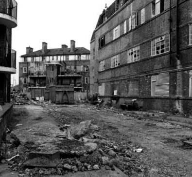
Post-war repairs were carried out, and people moved back in.  Photographs of the area in the early 50s shows people milling around, cars parked all along the roads, suggesting a generally well used residential area.  But when the docks began to close in the 1960s and work became hard to find, people moved away to find work, and most of Redriff Estate became derelict.   By the mid 1970s there was an uncomfortable mixture of paying tenants and squatters.  There is a brilliant set of colour photographs on Flickr of the estate in the late late 70s by Dave.P.C. at   (with thanks to @E44Blackwall for sending me the link on Twitter).

Author Ben Trovato, who was then unknown, wrote about inhabiting one of the squats on the estate in 1983, in an article called Squat Property on the Times Live, ZA website.  The link is now dead, and I've been unable to find a copy of it anywhere else, but I copied an excerpt from it at the time, which is sufficiently evocative of the article as a whole:
We’ve already picked out a ground-floor flat. Sticking to the shadows, we reach the door and go to work on the lock. It takes three minutes for the hacksaw blade to snap. The crowbar is no help. Nor are the screwdrivers. This leaves the sledge hammer. I pick it up with both hands and am about to deliver a death blow when a police siren cuts through the fog. We grab the tools and make it to the stairwell just as a sleek, white Rover veers into the estate. Cops pile out of it and begin searching an area 50m from us. They leave. We exhale. Ten minutes later, the lock shatters and the artist uses his Doc Marten boot to open the door. We replace the lock and become the legal occupants. Vote Labour. It seems too good to be true. A clean three-bedroom flat with a view of the Thames for which no rent will ever be paid or demanded. Sure, there is no electricity, gas or hot water, but we can’t exactly complain to the council.  After weeks of living by candlelight, which doubles as our central heating, we meet a gentleman who shows us how to bypass the meter for the price of a bottle of rum. Rotherhithe is a rough area, no doubt about it. There are half a dozen heroin dealers living within a five minute walk of one another. Some squatters have their cars set alight at night. Punks, skinheads and anarchists share an uneasy existence alongside angry, rent-paying Cockneys. These legitimate tenants hate us for living in flats identical to theirs, but for free. I come home one night to find “Squatters Will Die” spray- painted across the door.

Even the squatters left eventually, as described in an article by Sonia Soltani on the building.co.uk website entitled How do we get from this ...... to this?
Rotherhithe's derelict Redriff Estate, before
its 1980s rebuild.
The Redriff Estate on the fringe of London Docklands had all the problems of a typical rundown estate - and worse. When even squatters abandoned the derelict estate in the early 1980s, the alarm bells rang. Built around the perimeter of the Rotherhithe peninsula in south-east London in the 1930s as model local authority rented homes for dockers and their families, the Downtown Estates, to which Redriff belongs, were in a dire state 20 years ago, little more than a collection of burnt out shells. The decline of this part of the London Docklands after the Second World War was such that its only claim to fame was being used as a setting for war films such as Full Metal Jacket.

It was also used in the 1986 pilot episode of the 1980s television series London's Burning - photos of which are on Twitter at https://twitter.com/e44blackwall/status/526803231566229504.

However, as part of the London Dockland Development Corporation plans for a regenerated Rotherhithe, the entire estate was refurbished, as the article goes on to explain:

In the 1980s the dramatic juxtaposition of new upmarket private housing in London Docklands with the obvious poverty of the other docklands boroughs led Southwark council to transfer its vandalised squats to the London Docklands Development Corporation. This allowed the LDDC, local housing associations and the private sector to create a major mixed-tenure scheme. The amount of money poured into the project revealed the faith in the area's potential. The £55m Redriff Initiative on the Redriff Estate benefited from the largest ever single grant from the Housing Corporation - £22m. The rest of the funding came from the LDDC, a combination of public and private sector investment and Southwark council. A client consortium was set up comprising six locally based housing associations (South London Family Housing Association/Crystal Palace HA, Shackleton HA, Wandle HA, Housing for Women, Carr-Gomm HA and Peckham and Dulwich HA) together with Southwark council, the Housing Corporation and the LDDC. 

Although one block was demolished, formerly located on Odessa Street, 229 homes were created on the Redriff Estate for rent and shared ownership. A school and community facilities that had been located in the centre of the estate were demolished and this area was landscaped with additional car-parking areas added.  Part of the job was given to a private company:  Barratt East London, established in 1983 under project manager Alastair Baird.  It's nice to be able to credit Barratt with something good for a change (don't get me started on Ontario Point again). Sonia Soltani quotes Baird's recollections of the work: 
"We cleared the wreckage, from burned out cars to discarded drug needles, and then stripped out the shells, including all walls that were not load-bearing, which gave us the chance to reconfigure the flats. They were then re-roofed, re-floored and totally refurbished to provide modern conveniences such as fully-fitted kitchens and en suite bathrooms, increased levels of thermal and sound insulation, full heating, modern integrated wiring, and disabled facilities and access where required."

Bow-ended balconies were added, outside areas landscaped and parking space was expanded. Bright blue, red and green paint cheered things up considerably, nicely complementing the dark yellow brick.  
Barratt was fortunate with Redriff in that the buildings are traditional brick, rather than the sometimes more problematic system-built concrete. Also, there were no structural problems to contend with. Baird points out that all the original external features remained: "You've got character here. We've kept the character of this. It's better if you can keep the original features."

Flats are now occupied by both council tenants and private owners.  Wandering through on a sunny day, Redriff Estate has a range of colours and shapes to it that many estates simply lack.   It contrasts notably to the bland modern block opposite, New Caledonia Wharf, which lacks any of the warmth and variety of the far older Redriff Estate. 


The corner of Walker House
Photograph by Andie Byrnes


Walker House

Walker House arch

Elgar Street flats, showing decorative
brickwork. Photograph by Andie Byrnes


The corner of Gulliver Street and Elgar Street. 
Photograph by Chris Lordan,
under Creative Commons licence.


Particular thanks to the websites UK Housing Wiki and
Sonia Soltani's article
How do we get from this ...... to this? 


Saturday, February 21, 2015

Rotherhithe's Downtown area


Rotherhithe in 1914, with
Rotherhithe village to the west and
Downtown to the east
Downtown is the area along Rotherhithe Street that sits in the area behind Surrey Docks Farm.  Trinity Church, which was destroyed during the war and replaced by a 1950s version that stands today, was built to serve the Downtown area, and had its own school room attached for local children (I've written about Trinity Church on an earlier post).  Downtown was a village in its own right, just as Rotherhithe village to its west was. Stuart Rankin describes it as:
"formerly a self-contained community with its own church, chapels, schools, shops and pubs.  It was separated from the rest of the civil parish by the great sweep of the docks and the swing bridges giving access to them.  It was said in the 1890s that some elderly residents had never travelled as far as Lower Road."   

Trinity Church, on which work began in 1837
Downtown and the area that we now know as Rotherhithe village were therefore two distinct entities in the Rotherhithe peninsula, connected to each other by Rotherhithe Street, but separated from each other by the docks and probably by the less definable sense of being two separate communities, particularly as their social infrastructure, with a church, school, pubs and other facilities became established and formed the centres of local activity.  People had no need to travel away from the community to find what they needed, and Downtown developed a personality of its own.

Downtown was downriver from both Rotherhithe village and London itself.  If it does not refer to its downriver location I don't know where the name Downtown would have come from, but I am sure that the fact that it was named at all derives from the idea that this was a community in its own right.  It seems likely, looking at the maps of the area, that the Downtown area's housing, consisting of terraces of small houses, was built to accommodate the infusion of dock workers and their families.

The heart of Downtown in 1868. The abrubt
bend of the road to the right is where today the
C10 bus turns off Salter Road to turn down
Rotherhithe Street, past Trinity Church on the
left and the Surrey Docks Farm on the right
The 1868 map shows a small community sandwiched between Acorn Yard and the docks to the west and the Thames with its wharves to the west.  The river frontage included the massive Acorn Wharf timber yard (now Surrey Docks Farm and formerly one of the shipyards of the magnificent Barnard shipbuilding family),  the even bigger Durand's Wharf, Trinity Wharf, Queen's Wharf, the tiny Albion Wharf, a cooperage, another big timber yard, a number of saw mills and Nelson's Dockyard. All of these will eventually be covered in future posts - there's enough to keep me going for another decade!

Whereas today Rotherhithe village, much further along Rotherhithe Street, almost on the opposite side of the peninsula, has a clearly distinctive personality based around St Mary Rotherhithe church, Downtown was bombed fairly catastrophically during the war and retains little of its original architecture.

Trinity Church and its vicarage were destroyed by bombing on 7th September 1940, the first night of the 39-day London Blitz, a tragically memorable day for London.  At 5.30pm 348 German bombers dropped incendiary bombs on London.  A distribution map compiled from Fire Brigade records shows where and how densely the bombs fell on that day across London. Another map, on the Guardian website, shows where they fell in Rotherhithe. The bombs hit Rotherhithe so badly that the fires were uncontrollable and had to be left to burn themselves out, largely due to the intensity of the fires in the timber yards. The area was evacuated and much of the Downtown area of Rotherhithe was lost in the blaze.  Trinity Church was one of the first churches to be destroyed by German bombing.  All that now survives of its interior is a charred metal cross, with a figure of Jesus, returned to Holy Trinity in 2002. In the modern churchyard are some of the old churchyard's rather lovely tombstones, leaned up against the churchyard wall.  As a result of the war, the area has been radically developed since the 1930s, particularly during the 1990s.

However, one or two local buildings survived the Blitz, including what became known as the Dockland Settlement, the fourth location for a charity started by a wealthy playwright called Reginald Kennedy Cox (http://www.docklandsettlements.org.uk/).  The Dockland Settlement incorporated what was clearly once a rather nice chapel, the Ebenezer Chapel (a Norwegian place of worship and seamen mission), together with a contemporary two storey house, which was also obviously once very attractive. The Ebenezer Chapel and the attached house were recorded by archaeologists of the AOC Archaeology Group before it was demolished, and that 33 page report can be found here on the Archaeology Data Service website.  It describes the chapel as follows:  "This was built in 1871 for the local Norwegian population. This building was recorded to Level 2 standard as defined by English Heritage Guidelines."  The photograph on this post is a screen-grab from that report, showing the Ebenezer Chapel, that stood at the site until recently.  There's a brief but good explanation of the background to the word Ebenezer (not a name, as I ignorantly thought, but from the Hebrew, meaning "stone of help") on the Missouri Conference website: http://www.moumethodist.org/news/detail/831.

The pastor's house was attached to the chapel.  This was a two storey building with a hipped slate roof that was probably contemporary with the chapel and certainly dated to the 1870s.   The Dockland settlement, complete with chapel and pastor's house, was demolished to make way for a new block of flats in 2013.


The 1870s Pastor's House, before demolition
(from the AOC Archaeology Group report)

Ebenzer Chapel, 1871, showing the porch to the southeast of the nave
(from the AOC Archaeology Group report)


The new development on the corner of
Odessa Street, where the Ebenezer Chapel and the
Pastor's house once stood, February 2015


Monday, January 27, 2014

A short history of South Dock, Rotherhithe, 1811 - 2014


East Country Dock, bottom right in
1828.  Immediately to its north is
Greenland Dock. Click to
enlarge the image.
Only two of the docks that were built in the 19th Century are preserved in their entirety today:  Greenland Dock and South Dock (sometimes known as Sweden Dock), both at the east side of Rotherhithe peninsula and connected to each other by a small channel.  South Dock, today London's biggest marina, is the only one of the two docks to maintain its operational connection to the Thames.  To see how South Dock fits into the history of Rotherhithe's docks, see the post The Development of the Surrey Commercial Dock System 1699-1909.

I have had to keep some of the photographs in this post small to fit them all in to the text, but if you click on them they will expand to full size so that you can see them in greater detail. 

The granite bollards of the
East Country Dock are unique
on Rotherhithe
South Dock began life as the East Country Dock in 1811 by the East Country Dock Company. Ralph Dodd was the engineer originally hired to build it in 1801, on a considerable wage of £600 a year. He was a rather mixed blessing, full of ideas but not always the best person to execute them.  In 1802 he fell out of favour with the Eastern Dock Company and he was given a gratuity and dismissed as engineer, apparently because he was simultaneously engaged on other work and his fees were too high. Whatever the reason for his dismissal, he was quickly replaced.

The dock first appears on maps in the early 19th Century as East Country Dock, clearly shown on maps in Smiths Map of 1828, Cary's map of 1837, and Davies's 1843 map as a long thin, dock, as long as Greenland Dock was at that time, but around a quarter of its width.  It is difficult to imagine why such a long, thin dock was considered to be advantageous.  The East Country Dock Company, which was formed in 1807 and was named for its trading connections with the eastern Baltic.  

The East Country Dock was not connected to Greenland Dock, which was owned by a rival company, and it therefore required its own lock out onto the Thames. The dock was built specifically for the Baltic timber trade.  It is thought that the distinctive granite bollards that dot the edges of the dock probably date to this time.  

Weller map, 1868
Although attempts were made to take over the dock, the East Country Dock Company retained its ownership of the dock until 1850 when the dock was purchased for £40,000 by the Commercial Dock Company, which was already developing vast areas of Rotherhithe for mercantile use. 

Over the next two years, between 1850 and 1852, the Commercial Dock Company expanded the dock, doubling its width at a cost of £190,000, extending its area to 5061 acres and its depth to 27ft. It became known as South Dock and it was connected to Greenland Dock and the rest of the Commercial Dock network to the north. It was designed and overseen by important engineer James Walker, who was also responsible for major extension work at Greenland Dock.  There is a bust of him on a tall plinth overlooking Greenland Dock outside the Moby Dick pub.  The lock has walls of sandstone ashlar.  It now measured 48ft wide and, somewhat oddly, was only 25ft deep, meaning that it was 2 feet shallower than the dock itself.  A newly designed self-acting sluice was installed in 1855 is preserved.

A painting from 1888 showing
a view from the same standpoint
(Museum of London Docklands)
A connection to the rail network was established in 1855, which linked South Dock, Greenland Dock and Norway Dock.

In the same year James Walker's swing bridge was erected across the lock.  It was moved in 1987 to Greenland Dock, where it crosses Norway cut. In 1862 Henry Grissell's swing bridge was installed across the entrance lock.  Although it is no longer there, this bridge can also still be seen as it was moved in 1860 by the Port of London Authority to cross Steelyard Cut, the connecting channel that runs between South Dock and Greenland Dock.

A photograph taken in the late 1870s shows Steelyard Cut with some low buildings stationed along the quay, and sailing ships and lighters dotted around the docks, with a tug in the foreground. An 1888 painting of the dock by Tatton Mather, on display at the Museum of Docklands, shows a remarkably similar similar scene from a very similar vantage point, but with some much taller and very elegant brick warehouses situated behind the lower buildings shown in the 1870s photograph.

A photograph from  the late 1920s, showing an aerial view of a busy Greenland Dock and South Dock, shows the same buildings to the north of Steelyard Cut. The bridge in the painting looks very like the one in the 1870s photograph.

South Dock, bottom right,shown by sculptor Michael
Rizzello as it was in 1896. Stave Hill.
Today, the cut survives and is flanked by Henry Grissell's 1862 swing bridge, which was moved there at a later date from its original position across the entrance lock to South Dock.  The buildings were lost during the Second World War and have now been replaced by modern housing. 

In 1865 the two dock operating companies, The Commercial Docks Company and the Grand Surrey Docks and Canal Company, amalgamated to form one big company, the Surrey Commercial Docks Company.  

South Dock warehouse in the
late 1870s, with the lock
entrance and hydralic capstan
in the foreground
By the late 1890s both South Dock and Greenland Dock (which, at that time, was much shorter than it is today) had locks onto the river and were connected to each other and, via Greenland Dock, to a whole network of timber ponds, basins and the Grand Surrey Canal.  To the south of them a road ran from east to west, continuing up the eastern side of South Dock and crossing the Grand Surrey Canal to the south.  The Grand Surrey Canal passed uninterrupted to the south of both, linking Surrey Basin in the west of Rotherhithe with the rest of the canal which headed first east and then south towards Peckham.  Rotherhithe was a vast mosaic of docks, basins and timber ponds flanked by endless warehouses.  Housing, small shops and pubs were all confined to the edges of the river, where they rubbed shoulders with ship repair and related services.  It is all beautifully captured in Michael Rizzello's 1896 sculpture of Rotherhithe, which sits on the top of Stave Hill.

As the docks became busy and settlements grew up around them, requirements for improved public services became obvious, and local churches and schools were established.  Trinity Church, in the nearby Downtown area, was established in 1838 with a small school, and St Barnabas on Plough Way was built in 1872, with its associated school opening in 1874.  In the late 1890s Greenland Dock was extended, meaning that the Grand Surrey Canal now crossed the middle of it, but still passed beneath the end of South Dock.  The tiny building on the corner of Rope Street and Sweden Gate, known as the Yard Office was the old toll building for the canal, and was built in 1902 after the extension of Greenland Dock.  The extension of Greenland Dock also required the diversion of the road that used to run parallel to the canal and the early termination of the railway at South Dock, whereas it formerly ran to Norway Dock.

The Dog and Duck public house, Rotherhithe
The airship and aircraft bombings of the First World War did not damage the dock, but it fell victim to the more intense and targeted Luftwaffe bombing of the Second World War.  The lock was badly damaged and was sealed until after the war.  In 1944 the connection with Steelyard Cut was sealed off, the dock was drained, the floor was spread with rubble and the dock was used for the construction of concrete sections for Mulberry Harbour units. Mulberry Harbours were modular units which, when assembled, were used to create temporary harbours.  They were used for the Normandy beach landings. When they were complete, Steelyard Cut was re-opened, the dock was refilled via Greenland Dock, and the sections were floated out onto the Thames through Greenland Dock's entrance lock.  Warehouses were also hit, and one of the more notable casualties of the bombings was the Dog and Duck public house, which sat at the end of South Dock and had been there in some form since at least 1723.  All that remains of it is the name of the Dog and Duck staircase, one of a whole series of watermen's stairs that are found all along Rotherhithe's foreshore. 

After the war, South Dock's entrance lock was repaired and warehouses were replaced.  Although the docks had a brief period of revival following the war, traffic fell off for a number of reasons, mainly due to containerization of cargo and the specialized handling equipment, large docks and entrance locks required. The Surrey Commercial Docks closed in 1969, the end of an era.  Most of the docks, including South Dock, were filled in, although South Dock and others were re-excavated later as part of the regeneration plans, to bring the local heritage to life once again, and to add attractive water features to the area for the benefit of residents.

At some point, possibly during the late 1950s or early 1960s a set of very ugly warehouses were built on the eastern side of South Dock. These warehouses were still in place when the London Docklands Development Corporation began to redevelop South Dock. The London Docklands Development Corporation (LDDC), which operated between 1981 and 1994, had already achieved success in its Canary Wharf developments on the Isle of Dogs, in spite of considerable opposition from local residents.  Their work at Rotherhithe followed that success.  One of the LDDC's first projects at South Dock was to commission the lock control building, which overlooks the hydraulically operated lock at South Dock.  Built by Conran Roche between 1986-9 it looks remarkably like a very short air traffic control tower with a bowed control room and reflective glass, on a cantilevered pedestal.

Before and after - the
Plough Way warehouses
and the modern homes that
replaced them
Although the LDDC had few financial resources of its own it did own land and was therefore in a position to work closely with developers to regenerated the derelict docks.  A lot of surrounding buildings were still standing, although abandoned and completely derelict, and these were knocked down by the LDDC.  The vision for Rotherhithe was rather different from its plans for Canary Wharf, and focused primarily on the development of the area for residential purposes.

One of the earliest residential developments was Baltic Quay at the end of South Dock.  People purchasing apartments in the landmark building must have been taking a huge gamble on the potential success of the Rotherhithe venture, with the derelict 60s warehouses  still standing, great gaping eyesores amidst the optimism of the LDDC's plans for regeneration.  Falling on the Deptford side of the Southwark-Deptford border, which ran along the eastern side of South Dock's quay, the fell outside of the London Docklands Development Corporation's dockland regeneration remit, and were therefore not knocked down until the mid 1990s.  Although the docks themselves were closed to shipping in 1969, many of the warehouses continued in use, and the South Dock warehouses in the photograph were employed as bonded warehouses.  Containers of goods were delivered and stored there prior to distribution.  The photograph above shows the warehouses as they were shortly before they were abandoned, but they were much worse in the early 90s when I first saw them with wide hollow entrances to the starkly desolate and rather alarming wind-tunnel interiors, their floors covered in debris and shattered glass, broken windows rattling in the wind.

Baltic Quay
The massive Baltic Quay complex was built by Lister Drew Haines Barrow, opening in 1990. Visible from miles around and always recognizable due to its vast arched roofs, it is probably the most distinctive and imaginative of all the tall buildings on Rotherhithe. When it was built it was envisaged as a combination of office space with apartments above, but the demand for residential space far exceeded that of commercial offices and, apart from the ground floor, the office space was converted for residential use by Barlow Henley Architects.   Eventually the office space on the ground floor was also converted to apartments.  Baltic Quay will be covered on another post.  It reaches fourteen storeys. Its external metalwork was first painted  in a lively combination of blue and yellow, making it bright and welcoming, but more recent counsel clearly decided that this was a bad idea and it is now uniformly pale grey. The photograph here shows it after it was given its London-grey colouring.

Swedish Quays
On the West side, with views over either Greenland Dock or South Dock, a smaller complex was built between 1985  and 1990 by David Price and Gordon Cullen, named Swedish Quays.  Although rather more conservative than Baltic Quay, mainly due to its smaller scale, its brick construction and deep brown colouring, it still stands out as something somewhat different from the normal bricks-and-mortar style the dominates dockland and canal-side developments throughout the country thanks to cream rendering, tall columns, interestingly arranged glass panels, arched windows at the top of the buildings and something of an echo, however elusive, of Charles Rennie Mackintosh and other turn of the 20th Century designers. 

Modern apartments
overlooking the entrance
lock at South Dock
on Rope Street
When the warehouses on the east side of the dock were pulled down, they were replaced with the three-storey residential complex that remains today, overlooking South Dock on the one side and Plough Way on the other. (shown on the above before-and-after photograph) Rainbow Quay was added next to Swedish Quays.  Later, three-floor apartments were built over their garages behind the dock office at the Thames end of Rope Street. Their appearance, with facades consisting of  wood-lined curved bays on the two lower floors and top recessed floors above, are unusual and not to everyone's taste, but they do contribute diversity to the often bland local architecture.  

Today South Dock is London's largest private marina, providing both temporary and residential moorings on around 200 berths. It is operated by Southwark Council.  If you are keen on boats, old and new, big and small, this is a great place to take a stroll.  It is home to everything from narrow-boats, converted Humber keels and Dutch barges to wind-powered vessels of all sizes, alongside all sorts of strange and bewildering works-in progress.  Some of these boats are stunning, some are frankly hideous (particularly where lovely old hulls have been sabotaged with appalling conversions for habitation), but all are fascinating.  Some have been moored there longer than I have lived here and feel like old friends.  The Steelyard Cut still connects South and Greenland Docks, and the marina extends into the top end of Greenland Dock.  A modern lift bridge enables Rope Street to pass over the cut whilst allowing vessels to pass between the two docks.  Entrance to the marina is still via South Dock, the Greenland Dock having been blocked off after the closure of the docks in 1969.  The new hydraulic lock gates were added in the mid 1980s.

Rainbow Quay
Between them Greenland Dock and South Dock offer a peaceful atmosphere with a wide variety of modern architectural styles flanking their former quays.  At the same time, there are many features of the docks that survive and they provide a glimpse of a very different dockland past.

Once associated with a busy and often chaotic commercial activities, the docks now form the heart of a residential area that is characterized by its much-appreciated tranquility.  But the traces of its vibrant history, even after the Luftwaffe attacks and massive regeneration work, can still be observed by those who have an interest and take the time to look.


Steelyard Cut.  The modern Rope Street lift bridge and the 1862 swing bridge by Henry Grissell


Now crossing the Norway Dock entrance from
Greenland Dock, this bridge originally crossed
South Dock, where it was established
in 1855.  It was moved by the LDDC in 1987.


The old warehouses on South Dock
before demolition, with Aragon Tower in the
background before the redevelopment
of the Pepys Estate