Saturday, August 31, 2013

Burning Ground and the Condemned Hole

The Custom Building, "Condemned Hole,"
on the 1914 Ordnance Survey map
After around 1908 the space now occupied by the dismally monochrome 1960s block of flats called Custom House Reach, and the former Downtown nightclub, both on Odessa Street (SE16 7LX), was known locally as the "Condemned Hole." Before that, the site was known, with equal informality and amiable disrespect, as the "Burning Ground."

 The "Burning Ground" was so-named because contraband collected from smuggling operations along the Thames was usually destroyed at the site's incinerator, which consisted of a furnace and a tall chimney.  There were a number of such sites along the Thames, known collectively as the "Queen's Pipes."  The Customs Journal of December 1962 says that up until around 1908 "smuggled or condemned tobacco, illicit books, condemned food and clothing etc, were condemned by burning."  Smuggled tobacco was often burned here, and gave this particular chimney, the last of the contraband incinerators, the nickname "The King's Pipe."

"Burning Ground" soon became "Condemned Hole," the local name for the H.M Customs and Excise office based here.  Its wonderful name "magnetized" A.G. Linney when he wrote about it in Peepshow at the Port of London.  During much of the 18th century, the H.M. Customs and Excise property extended over much of the area between the red Scotch derrick (crane) and Odessa Wharf. H.M. Custom and Excise had a number of roles in the area.  Principal amongst these was to process items that were found floating in the river, known as flotsam.  Linney's description of approaching the Customs offices is unexpected:

"If you knew how to approach 'Condemned Hole' by land, you will presently bring up before an inconspicuous door in an inconspicuous and wholly dismal little street in Rotherhithe.  It is commonplace to remark that London is the City of Great Surprises; that door in the wall was one of htem, for I found myself looking at a cottage that might have been in Masham (Yorks), or Chipping Norton (Oxon), or Haverhill (Essex), or Brackley (Northants); in fact, in almost any small English country town between Cleveland and the Downs.  Creepers grew on its garden walls, there was a tiny grass plot and a garden filled with just the sort of blooms one expects in cottage gardens - the essential English cottage-iness of the place fairly took my breath away."

Linney believed that one of the buildings at 'Condemned Hole" was once used as a sail-loft when craft came to renew their sails.  The site included a number of sheds including one for painting and repairing boats owned by the H.M. Customs service and another for storage, that Linney says was made up of timbers from broken up ships.

Condemned Hole in 1937 and 2000 (the
black and white block marks the old site)
The items rescued from the river due to having been lost overboard or during collision were held at the site until they could be returned to their owners, where known, or sold off by tender (when the finder received a portion of the price).  On the Thames side of the yard the custodian, who had worked there for 25 years, showed Linney a platform where the rescued items were stored, which included an impressive list of diverse objects including planks, barrels, timber, tarpaulins, rolls of newsprint, wooden gratings, an immense number of barge poles and sweeps," and a curiously shaped gaily-painted boat" which turned out to be a Guernsey boat found derelict in the Channel.  The Customs Journal of December 1962 adds boats, rubber, cheese, a barrage balloon, and a live greyhound to the list! Timber was always desirable and according to a number of accounts gained a good price. 

There's a lovely description by Ernest G. Murray in Tales of a Lighterman, in which he describes picking up old rope to sell to "ropies," who were the same "boaties" who were also always in the market for the acquisition of "quality timber become salvage by falling - not always by accident - off the back of barges.  It went for auction at Condemned Hole, a percentage to the salvager who settled up with the bargee later in Charlie Lunn's Tea Romms [sic], the Ship and Whale or Dock and Duck."

The area that it occupied shrank so that by the 20th century it was confined to the site now occupied by the block of flats.  It is shown in the 1937 photographic record of the Thames shown in London's Changing Riverscape (Craig et al), but there's very little to see; it is included here because it is the only old photograph of the site that I have managed to find so far.  

The operation was closed in 1962, only a few years before the Surrey Commercial Docks themselves closed.  The Customs Journal gave it a rather nice send-off, and indicated that some of the remarkably unusual cottage personality described by Linney was maintained until at least this point in time:  
"It seems likely that we may be losing our Burning Ground from London Port.  This small area of Rotherhithe, comprising an official residence, a store and a garden complete with summer house and vines, is shown in the local maps as the Condemned Hole.  This was due to the old men-o'-war that were formerly broken up nearby."

One can understand why the developers of Custom House Reach chose to name the block of flats after the former Custom House, rather than its earlier more colloquial names, but what a lost opportunity! :-)

Friday, August 30, 2013

More from the foreshore - walking the watermen's stairs

Underside of a piece of clay tobacco pipe,
found at Horns Stairs, with some very
delicate leaf decoration where the bowl begins,
and the characters A and O either side of the heel
I checked the PLA tide tables went for a walk around the perimeter of Rotherhithe on Thursday (yesterday) to see where the steps that lead down to the foreshore are located, and what the differences are between the accessible foreshore areas.  It was another lovely day and a very enjoyable walk, looking down at the water's edge as well as at the buildings opposite.

There are a number of staircases still functioning that lead from the Thames Path down to the water, once the watermen's stairs which were used by "watermen" who operated small passenger boats and accessed them via the staircases between the built up waterfront buildings, and had their own association, the Company of Watermen and Lightermen. There used to be 13 staircases in Rotherhithe. The general public could also access the river by public rights of way, which enabled them to access the river from Rotherhithe Street to pick up passenger boats.  The best known of these, due to the preservation of its sign, is the one that runs down the eastern side of the Mayflower public house (whilst the Church Stairs ran down the western side of the same pub).
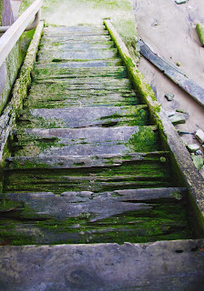
Horns Stairs
Following on from my previous health-and-safety type comments about the foreshore itself, the stairs do require a bit of a warning too.  At this time of the year the weed visible in the photo to the left is dry by low tide, but during the winter these weeds are incredibly slippery and with or without weeds, the lowest steps require caution just because of the residual mud.  Most of the staircases have handrails but the general rule is that it's important not be gung-ho about either the stairs or the foreshore itself.

Starting downriver (at the eastern extent of Rotherhithe), the first is the set of stairs by South Dock, which were named the Dog and Duck Stairs after a nearby pub that was destroyed during WWII.  The stairs lead to the section immediately beneath the Thames Clipper pier, and it is a very small area of foreshore, which I have never seen connect to other areas of the foreshore and is always penned in by water.  I didn't go down, although it is accessible through a gate that isn't locked, but it looks worth a visit.

The next set of stairs are the Acorn Stairs immediately upriver from the Surrey Docks Farm, where the Lottery project has been working (and will be continuing to work in September).  These stairs were also named after a pub that no longer stands due to war damage.  I've already talked about the foreshore on a recent previous post, so I won't repeat myself here. I took the stairs back up to the Thames Path to walk to the next set of steps, but if you are prepared to brave the mud in front of the Nelson dry-dock (wellies essential, because it is very sludgy and has a lot of suction), you can walk around the dock entrance to the Horns stairs at the Hilton Hotel.  Nelson Dock is built at a point in the Thames called Cuckold's Point, marking the point at which Limehouse Reach becomes Lower Pool.
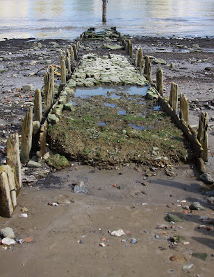
Former jetty at Horns Stairs
The stairs beyond Nelson Dock and the Hilton Hotel are at the point where you can rejoin the Thames Path at Canada Wharf after being forced to circle the Hilton along Rotherhithe Street, going up the steps. They are called the Horns Stairs. Again, they were named after a nearby pub, the Horns Tavern, which closed in 1896. The stairs are wooden (shown at the top of this post) and although they seem fairly structurally sound, are a bit unnerving due to all the gaps. At the bottom there is an area more like a beach than the shifting carpet of bricks and stones in front of the Surrey Docks Farm. Most of it is a beach-like surface with debris strewn along it, although there's an area where roughly shaped cream-coloured blocks are gathered, which may be the surviving remains of a local structure. With your back to the water, there are great views up to Columbia Wharf, the original 19th Century building that has been incorporated into the Hilton, and which has some very distinctive decorative brickwork.  It is also an opportunity to walk up and get a good view of the blocking caisson of one of the Nelson Dock's remaining dry docks, which now preserves Thomas Bilbe's patented slip.  When I first moved here the dry dock housed a small sailing ship called the Dame de Serk, which had been converted into a rather good restaurant, but the slip is now ship-free.

Today there were lots of seagulls, adults and juveniles, at the water's edge picking out something that was obviously providing them with some sort of food.  Although there are relatively few objects to be found on the beach, the dispersed nature of the debris means that it is easy to pick out individual items, and I picked up a nice piece of clay pipe - nothing very special but with a delicate piece of decoration on the tiny piece of the bowl that remained.  There is, however, a very interesting set of structural features immediately at the bottom of the stairs (see photo above). These mark the jetty and pier that once reached out over the mud for the ferry service to Limehouse Hole.  Former ferry piers and jetties are usually good places to search for objects at low tide, but the tides don't seem to favour collection of objects at this particular point.
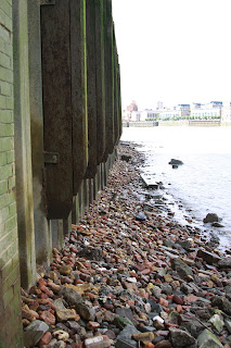
Narrow section of foreshore at
Pageants Stairs
The next set of stairs, still walking upriver towards Tower Bridge, are the Pageant Stairs, just beyond the obelisk at Pageant Crescent. The reason for the name of the stairs is unknown, because there doesn't seem to have been a pub of that name in the vicinity. The stairs are steep and lead down to a very narrow section of foreshore, which is liberally littered with stones and bricks, which seem to form quite a dense layer.  This is the part of the river where I really wouldn't recommend trying to get around the corner on the foreshore itself, because as you look upriver to the left it is very narrow even at low tide (see photo left).   But if you like picking out small objects, there was a lot here in amongst the fragmentary rubble.  The photograph at the end of the post, of the top of a ceramic vessel, with the original cork still in position, was taken here. I nearly got very wet feet here when Thames Clipper shot past and created a set of waves that travelled quite a long way up the very short sloping beach.  The barquetine mentioned in the previous post drifted past on her way to Tower Bridge as I stood here, and it was lovely to stand right at the river's edge and watch her go past.


Globe Stairs are located just downriver of Globe Wharf.  You need to pass through a small gate to access them, but this is not locked. The material here is much more fragmentary, reduced to a dark grey gravel over the decades.  There were very few surviving objects and the small number that I found were of the more robust variety, and were very water worn. It is just as well that it isn't a promising area for small finds discoveries because it felt more than a little intrusive to be walking around in such proximity to Globe Wharf, because it has been converted into apartments.  I could hear knives and forks on plates on a balcony above me, and there was a lovely aroma of garlic.  I was a lot happier wandering around where I didn't feel that I was disturbing someone's lunch by fossicking around at the water's edge outside their home.  On the other hand, if you like the 19th Century conversions along the riverfront, this is by far the best way to see the riverside frontage of Globe Wharf itself.  The 1914 Ordnance Survey map shows a jetty leading down to "Globe Stairs Pier,"  but there were no signs of the remains of this at the time I was there.
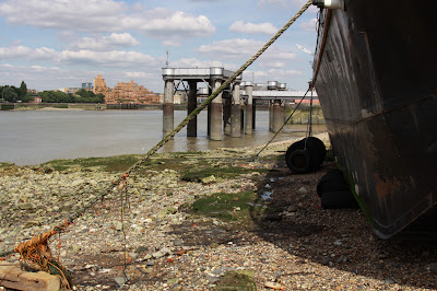
Under the bow of the houseboat at Hanover Stairs
Just beyond the 1882 gasworks pier, now known as Clarence Pier, and precisely where the ubiquitous houseboat is moored, is another staircase, the Hanover Stairs. Again, you need to pass through an unlocked gate.  At the bottom of the stairs you have to duck under a mooring chain to walk down onto the the foreshore, and you need to skirt the boat as it rests on the ground to walk back to the east, but it's not an obstruction. From here it is an easy walk along the foreshore to the next set of stairs at the Angel public house (the modern replacement for Kings Stairs), with views up to Tower Bridge.  The site either side of the stairs was occupied by Talbot and Brothers, who built wooden and iron hulled barges.  There are a lot of worked wood planks scattered around here, very large pieces that certainly come from old boats.  The Thames Discovery Programme has done survey work here in the past, and one of their short reports, with a table of their main findings, is currently available on Scribd.  Curved, carefully shaped and marked by holes where ship nails would have fitted, these timbers are a nice survival of the area's boat-building past.
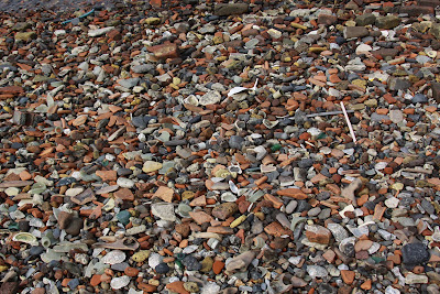
The foreshore at the Surrey Dock Stairs
This stretch of the river was much more like the Surrey Docks Farm stretch, with a lot of brickwork and stones extending over a very wide stretch of the foreshore.  It shelves quite steeply down to the river.  There were more pieces of clay pipe than I could actually get my head around, and a lot of very large and sharp pieces of glass.  A lot of china and coarse ceramics had washed up, and it was a kaleidoscope of colour and shapes.  I was by no means the only person pottering around in the stones and mud, and I suspect that this is a favourite place for people looking for goodies at the water's edge.  It is also possible to walk for a long way, there are some very attractive buildings above (which, if you want to get a good look at building frontages, are much best seen from the foreshore than the Thames Clipper, which moves so quickly along this stretch) and there are some great views of well known London sights, so it's a really nice place to go for a wander. 

Another set of stairs, Church Stairs, run down the side of the Mayflower public house but are inaccessible today thanks to a large locked gate. Horseferry Stairs used to be located midway down Sovereign Crescent but it, and the dry dock marked on the 1914 map of the area, have also vanished.  It's the same story for King and Queen Stairs, which were downriver from the modern Old Salt Quay public house.
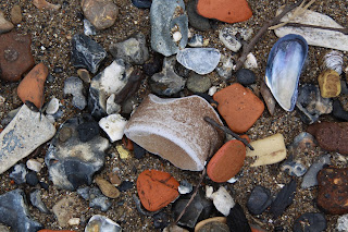
A colourful mix of oyster and mussel shells,
broken brick and Victorian ceramics.
At a very low tide, bearing in mind the very narrow stretch at Pageant's Stairs where you might have to paddle, you could probably walk from South Dock to the Angel public house along the foreshore. You can find this information from the Port of London Authority website, using North Woolwich as a guide, which not only gives you high and low tides but shows the heights estimated at those times.  Yesterday, for example, the low tides were at 0008 (1.39m) and 1227 (1.53m) and high tides were at 0639 (5.97m) and 1904 (5.88m).  With 4 metres between high tide and low tide, it is important to get this right :-).  On Saturday 21st at 0855 the tide is particularly low, at 0.57m, nearly a metre lower than Thursday's jaunt.

I walked back up to the red bascule bridge, crossed the road to Surrey Water, where a nice selection of water birds were enjoying the sunshine, and cut back to Greenland Dock via the Albion Channel, where there the water lilies are just coming into flower. I then crossed one of the bridges and went into the Russia Dock woodland.  It has been good, over the last few days, to see Russia Dock Woodland looking so neat and tidy, and so well used.
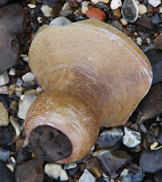
After four days in Paris and two obsessive days wandering around Rotherhithe, my feet were feeling the activity, but  my ankles hurt even more, because even though I have been nagging on about appropriate footwear, the weather has been so gorgeous that wellies, hiking boots or anything else that gets in the way of nicely aerated toes seemed so tedious.  All well and good on the area under the Hilton where it is just like a beach, but very tough on the ankles where the bricks and stones shift endlessly under foot.  Appropriate footwear is seriously recommended;  neon pink fashion trainers with no ankle support are not.  I was also wearing shorts, which are great on a sunny day, but the sheer amount of fresh glass under foot is astounding and slipping and falling could have been very messy.  I do recommend being careful about walking on the loose stone and brick, and taking measures against the sharp things that lurk under and in the mud.
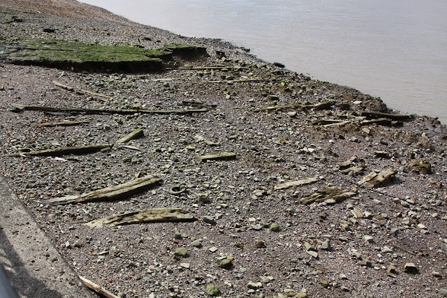


Timbers near Clarence Pier at the foot of Hanover Stairs,
surveyed some years ago by the Thames Discovery Programme


Thursday, August 29, 2013

Tall ships at Woolwich and beyond


Just a quick reminder that there are apparently tall ships up at Woolwich at the moment and over the weekend.  The Royal Greenwich website says that "from Wednesday 28 August to Sunday 1 September 2013 eight tall ships will be based along the riverside in Woolwich. They will be sailing up to central London each day and evening, departing from Woolwich pier."  More information is available on the Sail Greenwich website, and a route map is available on the site here.   It doesn't look as though they are going to form any sort of convoy or parade together, which is a shame, but the website is a bit of a mess and I may just have misread it or missed the critical bit - do let me know if you know of plans for all the ships to sail together along the Thames.

I saw one of the ships today as I was walking along the Thames Path.   Called Loth Lorien, (a reference to Tolkien's Lord of the Rings, according to Google), she sailed down to Tower Bridge, turned around and came back.  On her return journey she unfurled more sail than on her trip upriver and looked quite spectacular in the sunshine.  She was flying Netherlands and Amsterdam flags.  

A further rumble around Google revealed that she was built by Asselem and Karstens in Norway in 1907, is 48m long with a steel hull and is barquentine-rigged.  More details about her can be found on the Marine Traffic and Charter World websites. 

She looked absolutely lovely in the sunshine.


Clay tobacco pipe fragments from the Thames foreshore

Three unusually long pieces of clay pipe
from the Thames foreshore at Rotherhithe
Yesterday's pootle along the Thames foreshore between Surrey Docks Farm and the Hilton produced an awful lot of clay pipe, most of which consisted of small pieces of the shaft of pipes, some of which were very heavily weathered, but there were some bits of more interest.  A couple of the shaft pieces were unusually long.  Because most don't normally survive the battering of the Thames tides, they are usually only an inch or two long, but I stumbled across two that were over 6 inches long. One piece of a clay pipe shaft was decorated. 

I also found two pipe bowls, one of which was marked with a manufacturer's stamp ("EW").   I still haven't found who or when this stamp represents, but hope to do so shortly. I wanted to record them immediately before cleaning them up so that I had a record of them as they were when they were found and I hadn't washed my hands when I took the photos, so apologies for the poor quality of the shots, and the fact that my fingers and nails are glazed with mud!  I will take more photos of them when they have been cleaned.

As I posted yesterday, there's a small but helpful section about clay pipes on the Museum of London website and here on another of their pages.


Three short pieces of clay pipe and a
piece of decorated ceramic


Three pieces of heavily water-worn clay pipe,
where the shaft meets the bowl at the heel


My very dirty fingers holding the bowl of
one clay pipe to show the base of the heal,
marked EW (and again below)


A clay pipe bowl, with markings at the
base, either accidental or deliberate


A decorated piece of clay pipe shaft


A typical piece of unmarked clay pipe shaft with
the remains of the heal and the beginning
of the bowl


Wednesday, August 28, 2013

From Surrey Docks Farm to Nelson Dock along the foreshore

It was a beautiful day today so after several days of moving at museum-speed in Paris and several hours on the Eurostar, a tromp along the Thames foreshore seemed like a good idea, to loosen the limbs and get a sunshine fix.  

The easiest way to check the tide level is to look at the Tide Tables page on the Port of London Authority's website and use the North Woolwich low tide as a reasonable estimate.  Today it was at ll48, and when I arrived at the stairs next to the Surrey Docks Farm, the tide was still on its way out.

I wasn't sure how far I could get upriver without being up to the knees in mud, so I went to find out.  At low tide that took me as far as Nelson Dock, and my trainers were un-mudied.  I would have been wary at crossing in front of Nelson Dock because it was pure mud and no matter how safe people tell me it is, I've experienced that mud when wearing wellies and it has a lot of suction.

I didn't go with a view to finding anything in particular - I was just there for a stroll.  But having been involved in the Surrey Docks Farm survey (still working on documentary stuff) I was fascinated by all the odds and ends that are kicking around on the foreshore. None of them have financial value (unless you spend a lot of time rummaging in the mud, and get lucky), but many are really interesting just as a random sample of what washes up.  

The stone-covered beaches are full of small objects that have washed up over the decades, some easily identifiable, others a complete mystery (at least to me).  The bricks, stock bricks from the construction of may nineteenth century buildings, were bulldozed into the river after the bombings of the Second World War, a small reminder of the destruction and bits of our lost heritage.  The mud is full of timbers, chains, nails, bolts, all sorts of odds and ends from wrecked, broken up and damaged ships including surprising numbers of anchor parts that were apparently used to moor small boats and barges at low tide. Some of the steel cables, a piece of which I picked up, were rock solid. There was a simply staggering amount of bone.  There were numerous oyster shells, presumably from the Victorian period when oysters were gathered off the English coast and consumed in large numbers.

Today I saw dozens of white pieces of clay tobacco pipe shaft.  Clay pipes consist of a long tube of white clay, which makes up the shaft, finishing in a bowl, which often has a small heel to keep it upright when placed on a table. They were mass produced by the end of the 16th century (see the Museum of London's web page on the subject for more information), and as they were prone to snapping and could be easily replaced their remains are littered throughout the country, turning up in handfuls in fields, gardens, and of course rivers. There must be many thousands of fragments along the entire length of the Thames alone.    Some of these were marked with stamps, enabling their manufacturer to be identified and a date to be assigned. Pricier models were elaborated with little embellishments and sculptural features. A far greater number are unmarked, but all are remarkable, if only for the sheer volume of them remaining in fragmentary form.   Most of the bits I've found in the past have been completely unmarked, but today I found two which had been marked - one with a little line of decoration on the shaft, and one with a stamp on the base of its heel. 

I was unable to identify many of the items that I found.  A number of identical tiny silvery bottles, for example, may have been pharmaceutical jars but are round-bottomed and I suspect actually belonged to machines, partially because the glass or glass-like fabric is so very strong.  They are very vaguely familiar, but I am not at all sure where from (see photo right).

Overall, there was a lot of ceramic and coarse pottery - everything from willow-pattern china to bits of flower pot, chimney and coarse ware.  There were also a lot big fragments of thick clay jars and bottles, probably Edwardian and Victorian, judging from the stuff I used to dig when clearing down to the Roman layers on town sites.  

So much of what I picked up had been heavily rolled by the Thames and fragments of glass, stone pipe and pottery, which must have very sharp edges when first broken, were now rounded and smooth to the touch. 

There were, of course, the usual selection of items tossed unwanted into the river - lots of bits of bicycle, for example, a plastic chair, and the ruined remains of a Blackberry mobile phone.   But it was surprising how little ordinary rubbish there was.  The usual detritus of human living, plastic bottles, tin cans, crisp packets and the like, must be washing up somewhere else.

I was only there for a random hour's stroll, but there was so much to see. A couple of words of warning to those thinking of heading down to the foreshore, if you haven't been before.  Wellies are essential if you are getting off the stones and pebbles and going into the mud.  Even if you stick to the stones and pebbles, you need sensible footwear because the stones shift a lot beneath your feet and the bricks are slippery. In addition, there is a lot of broken glass, not just little bits but big broken bottles.  Importantly, the tide comes in very, very quickly, so it is essential to check the tide tables.  Finally, the mud can be nasty stuff, with all sorts of things decaying invisibly beneath it, so you if you are intent on picking up objects with your bare hands (waterproof gloves, like those used by the Thames Discovery people and other professionals, are a much, much better idea) then you absolutely must have tetanus shots.  These days they last for 10 years, and I never miss mine.


Friday, August 23, 2013

Planning and development at Quebec Way

Many thanks to Steve Cornish for the information that the Quebec Way Industrial Estate development will commence early September 2013.   Here are a couple of artist's impressions of what the site will look like, plus a site plan.  Quebec Way is the road that runs behind Surrey Quays Shopping Centre, leading to Canada Water and skirting the edge of Russia Dock Woodland.


Thursday, August 22, 2013

New website for the Friends of Russia Dock Woodland

The Friends of Russia Dock Woodland have just launched their new website.  Over the coming week the old website will be removed, so please update your bookmarks: www.fordw.org.uk.   

It will take a few weeks for the new site to show up on Google searches, so please keep a note of the new website address if you are a regular visitor to the site.

You will find the latest news, a new photo gallery (which will be expanded as people send in their contributions) together with plenty of information about the Russia Dock Woodland and the activities of the Friends, including keeping a weather eye on planning applications that might affect it.

The Russia Dock Woodland runs through the centre of Rotherhithe, and connects with Stave Hill Ecological Park.  Both the Friends and the Stave Hill teams work closely together to ensure that the ecology and general care of the sites are maintained to a very high standard.  A number of awards, most recently another Green Flag award, have recognized the efforts of all those who push for ongoing improvements for the benefit of both the public and the local wildlife.  

Walking in the woodland is a lovely way to spend an hour or so, and it is good to have a way of keeping abreast of all their latest news, updated regularly by the Secretary of the Friends.


Planning notification: 40 storey buildings at Canada Water

The 42 storey HSBC Tower. Canary Wharf
Photograph by Clive Power
The 15th August edition of Southwark News, which I've only just got around to reading, has a planning notification regarding the Canada Water area of Rotherhithe, which has been going through planning hoops for years.  I am, as usual with Southwark's planning strategy, confused.  The planning page for this application says that the target decision date is/was 14th May 2013, which is of course in the past, so I have no idea why they are publishing the planning request again.

If you are new to the area or have missed the consultation process, planning reference 12/AP/4126 concerns the demolition of the existing buildings on the site of the Decathlon and What retail stores (sites C and E) and the erection of five buildings ranging from 5 to 40 storeys. You can find full details at the Southwark Council website: http://bit.ly/13I21G3

Such a shame. Ontario Point, the new monolith next to Canada Water station, is a 26 storey building and that's already too massive. 40 Storeys is the size of Norman Foster's Gherkin (30 St Mary Axe), whilst the vast new Strata building at Elephant and Castle, is just three storeys taller at 43 floors.  The solidly dull HSBC tower in Canary Wharf is, at 42 storeys, joint 4th tallest building in the UK.

There's a useful Wikipedia page, for future reference, that shows the tallest buildings in London, just to enable one to get some sort of perspective on the sheer scale of some of these proposals and to get an idea of what sort of impact some of these planning applications are likely to have on the area, both practically and aesthetically. 


Wednesday, August 21, 2013

Learn about Southwark Park lichens

Thanks to Steve Cornish for forwarding this to me:


From: "Reast, Eleanor I"
Date:
21 August 2013 09:40:23 BST
Subject: Learn about lichens with an expert from the Natural History Museum!

Ever wondered what the colourful organisms growing on the trees, pavements and park benches in Southwark Park were? Do you know they’re called lichens but wanted to know more? Well here’s your chance to spend an afternoon with a lichen expert! Open Air Laboratories (OPAL) and leading lichenologist Dr. Pat Wolseley from the Natural History Museum will be able to show you the basics and help you discover some of the urban lichens growing in and around Southwark Park.

This free session will be on Wednesday 4th September from 1-5pm. It’s designed for complete beginners so all you need to bring is enthusiasm! It’s free but places are limited to 15 so booking is essential.

Please contact Eleanor Reast, OPAL Community Scientist on opal [at] imperial.ac.uk or phone the OPAL office on 02075 949295 to book your place.


Eleanor Reast
OPAL Community Scientist, London and South East

Centre for Environmental Policy
Imperial College London
South Kensington, London, SW7 1NA

The Scotch Derrick, Lawrence Wharf, Commercial Wharf and Commercial Dock Pier

At the northern end of Odessa Street, where the Thames Path resumes its riverside route towards Tower Bridge (SE16 7LX), there is a red derrick. Various sources state that was the last remnant of two companies, one called Kemp, Collins and Co., who operated out of the now vanished Commercial Wharf, and one called Vitak Ltd, who occupied neighbouring Lawrence Wharf. Both were timber importers, and the two wharves seem to have been amalgamated at some stage to form one large operation.  The area today is occupied by the derrick (or crane), the basketball court and the youth hostel, shown in pale green on the map below, as well as some modern housing that sits along the Thames path.  A of March 2015 the red derrick is now under threat from developers - please see the petition to save it at http://chn.ge/1EHzH2E.

The Commercial Wharf and Lawrence Wharf operations were separated by Barnard's Wharf to the north by a road that led straight up to the Thames and was perpendicular to it (the old Thames Street on the 1868 Ordnance Survey map, which had been renamed Odessa Street by 1894 – this gets a bit confusing when you think of today’s Odessa Street, so have a look at the map below where the road is highlighted in pale blue).

Commercial Dock Pier ran to meet the Barnard's Wharf along Odessa Street's northern edge and certainly seems to have been a part of the Barnard's Wharf operation by at least 1894, when it was linked into their network of travelling cranes.  This stretch of road is now the slope that leads up to the crane.  If you stand facing the Thames with the crane on your right, the pier would have stretched out before you, extending beyond the low tide muds out into Limehouse Reach.  

In 1894 the site was occupied mainly by one large building, which was not labelled on the Ordnance Survey map of that year.  Over the road, Commercial Wharf pier now linked to a network of travelling cranes that flanked a large open wet dock, the entire yard now labelled “Barnard’s Wharf” and it is unclear if the area occupied by Commercial Wharf was using, or had access to the pier.
Detail of the 1914 Godfrey Ordnance Survey map
By the time of the 1914 OS map Rotherhithe was a major timber processing centre, with six large timber ponds and numerous timber sheds, at the peak of its success.  At Commercial Wharf the 1894 building had been removed and only two small buildings are shown on the site, together with “Cranes,” circled in red on the map, and two mooring posts.  At Barnard’s Wharf, the network of crane tracks had been extended slightly but otherwise the site remains very much the same.  The cranes marked on the Scotch derrick site were not connected into that network, and again it is unclear whether or not the Commercial Dock Pier was accessible to those operating out of Commercial Wharf, or if the Commercial Wharf operation depended instead on cranes loading and unloading wood from the mooring posts marked on the 1914 map.

There is a 1937 photograph showing the derrick when it was still operational. surrounded by big piles of planks.  Similarly, next door at Barnard's Wharf vast piles of wood are shown stacked out in the open air.  Commercial Dock Pier is shown with two small huts on it, flanked by wooden dolphins.

1937 photograph, showing the Scotch derrick, nearly cat centre, at Commercial Dock Pier in the foreground.
From London's Changing Riverscape by Craig et al 2009 (see Bibliography for full details)


The term "Scotch derrick" describes a simple crane that was frequently used in quarries, docks and boatyards, some even fitted to ships in the mid 20th century.  They are also called stiff-leg derricks.  The difference between a crane and a derrick is that the jib (arm) can be raised or lowered on a derrick, rather than the jib remaining stationary. They were used for lifting and moving heavy loads, larger ones had control cabins and they were usually steam-powered.  As you can see in the last photograph on this post, the Commercial Wharf Scotch derrick extended over the river so that it could load and unload vessels.   

View of Commercial Wharf with the
Scotch derrick in the background,
1982. With thanks to Malcom T.
Tucker for the photograph.
All I have been able to find out about Kemp, Collins and Company is that they were a limited company established in 1899, engaged in timber and spar importing.  At this time the timber import business of Rotherhithe was already a success, with timber ponds and deal sheds predominating in the surrounding area. It was re-registered on the 9th March 1926 (company number 00212271). Its head office was in Sussex, and although it is recorded that the company was dissolved, there is no date for this.  There is a record of a Caroline Kemp, who was a director of the company in 1992, which implies that the company itself survived into the 90s in some form or other, even though their Rotherhithe wharf was apparently shut down at a much earlier date.

Vitak Timber Importers Ltd. (company number 0525906) was established in 1953, and part of its business operated out of Lawrence Wharf.  The company not only imported hardwood timber for processing at Lawrence Wharf but had a sawmill for at the site, thought to be the last remaining sawmill in London until it closed in 1986, when the family sold the business. 

Today, still mounted on a concrete column, the Scotch derrick is a monument to the wharf's past, and a reminder that this densely residential area was once something very different.  The old London Docklands Development Corporation's (LDDC) policy of preserving tangible pieces of the past was impressive.  The all-too-common loss of heritage for the development of apartment blocks, without any concern for giving residents a sense of the area's past, is always sad.


Vitak Timber Imports Ltd at LawrenceWhaf in the 1980s
Copyright Southwarkcollections.org.


The Scotch derrick today