Friday, February 28, 2014

Booth's Maps of London East and West Poverty 1889

In this pack two maps are included, representing west London and east London in 1889. Booth was a remarkable man who set out to assess how wealth was distributed across the main residential areas of London. His undertaking was staggering. Appalled by the poverty he witnessed in the dockland areas he set about colour coding every house in every street according to how well off the families who lived in them were. His lowest rank is "Lowest Class. Vicious, semi-criminal, going up to "Upper Middle and Upper Classes. Wealthy." Between the two he identified five classes to represent the "general condition of the inhabitants." The maps he created as a result of his research were used to tackle social problems derived from poverty, and to plan reforms.

The maps in this edition are presented in a card folder, each with its own envelope to protect it, connected by a spine. When you open the folder, the interior surfaces contain an introduction to Booth's maps, giving brief details of what London was like, what motivated Booth to create the maps and how they were used. It also expands on the keys shown on each map.

When you lie east and west side by side it is daunting to see how polarized they were in terms of poverty, with the east showing great areas at the blue (impoverished) end of the scale, whilst the yellow (the top end) are confined to the west (albeit with some blue patches crowded into nooks and crannies)

The maps are reproduced on good quality slightly shiny paper, with all-importantly good quality colour reproduction so that it is easy to make out which colours are which (Booth used incremental shades of blue and red, which could have been very difficult to distinguish from each other in an inferior quality edition). Road names are easy to pick out and a grid sits over the top (the space between the horizontal lines representing half a mile). This is a really excellent pair of maps and essential to anyone interested in late 1900s London.

Thanks very much to the anonymous person who posted a comment and reminded me that there is an online project run by the London School of Economics called "PhoneBooth" that enables you to view different parts of Booth's maps with a series of overlays of London, using the + and - signs to zoom in on areas of interest.  The application is in Beta testing at the moment, and is a bit clunky to use, but it is an excellent idea and with patience works really well. http://phone.booth.lse.ac.uk/

Thursday, February 27, 2014

Update re planning application to demolish the Ship York

The Ship York. Photograph by Stephen Harris
There have been a lot of rumours circulating over the last few days about whether or not the Ship York has been sold to developers and whether or not its planning application has been accepted.  As usual with Southwark Council's planning pages I am completely confused about what has and hasn't been agreed re the Ship York at 375 Rotherhithe Street.  On the one hand there is a planning application number 13/AP/2407 (http://bit.ly/1bOJ74c), that, near the end of the page, says simply "Decision: Granted."  On the other hand, there is also a planning application number 13/AP/3839 (http://bit.ly/1pygj3X) that states "Decision: Application not yet decided."  I have no idea what all this means in planning terms, but I assume that the writing is on the wall for the pub!  If anyone has more experience at interpreting these various contradictory reports I would be most grateful for a little basic elucidation.

According to the original planning application back in 2010 the existing three-storey (plus basement) building will be replaced by a five-storey (plus basement) mixed-use development comprising of a public house at basement and ground floor level, and 8 x two-bedroom residential units above.  The application didn't go through in 2010 but the new application is presumably doing something to resolve objections in the original planning application - though I have no idea what.

The condition that the new development should have space for a public house at ground floor and basement area is presumably supposed to tackle the fact that the area is becoming short of pubs but doesn't address the matter of how many buildings of the 1930s/40s era remain on Rotherhithe. As The Clipper is almost certain to be demolished (it has been sold to developers) and most local people feel that it is only a matter of time before the Orange Bull (formerly The Fitchetts, before it later became The Aardvark) goes the same way, the only two pubs to surivive from the period will be The Ship, over the other side of Rotherhithe, and the former Three Compasses, which is now a pizza restaurant.  Southwark Council has gone apartment mad.    

The building is an attractive one, and is a really nice corner of 1930s Rotherhithe in an area that has suffered a lot of really third rate modern development.   It is a shame that its owners and Southwark Council are so ready to see it eliminated from the architectural diversity of the area.


Sunday, February 23, 2014

The development of Albion Dock and the timber ponds of the Grand Surrey Dock and Canal Company

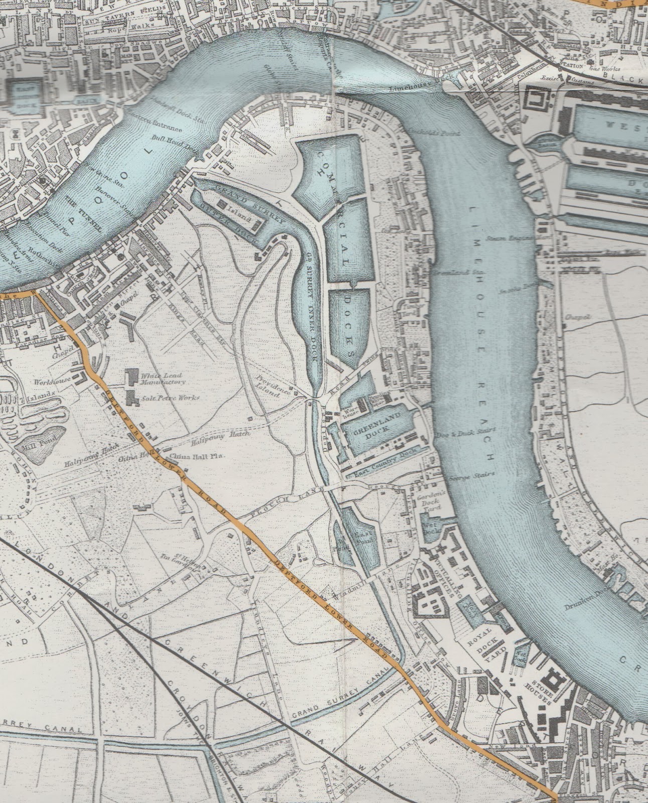
The Grand Surrey Canal Company was incorporated in 1801 to build the Grand Surrey Canal and, when this was complete, the canal passed across Rotherhithe and beneath Greenland Dock towards Deptford before turning south towards Camberwell (which opened in 1811) and Peckham.  See my earlier post about the development of the Grand Surrey Canal

The Grand Surrey Canal system in 1843 showing
the expansion of the canal to create dock areas
but before the addition of the new lock,
Surrey Basin, Albion Dock and the new
timber ponds.  Compare with the map below.
The Grand Surrey Canal was not the success that its planners and investors and hoped for, but they realized that they could develop both the canal and the surrounding areas to create inland docks of the sort already pioneered on Rotherhithe by the Commercial Dock Company (see my earlier post for the development of the CDC) . They applied for parliamentary permission to expand the the channel of the canal that led from the island basins that made up the Grand Surrey Outer Dock, and this was granted in 1811, allowing them to expand the canal to either side to form a dock with the canal flowing down the middle.  It was named the Grand Surrey Inner Dock, later being renamed Russia Dock.

The success of this venture confirmed to the Grand Surrey Canal Company that its future lay not in the canal but in the development of further inland docks.  In 1855 its named was changed to the Grand Surrey Docks and Canal Company, after which it set about modernizing and expanding in order to accommodate the larger and deeper vessels that were being built. The upgrades were necessary to accommodate a new and larger type of ship. When the Grand Surrey Canal was built, most of the ships traveling through the outer basins and the canal itself were wooden, and powered by sail.  With the advent of steam and the the development of steel hulls, ships became faster and bigger.  Older locks were often neither long enough nor deep enough to handle the bigger ships, and dock systems had to upgrade in order to remain competitive.  Bigger cargo holds meant a requirement for greater cargo handling efficiencies and storage facilities.  Steam ships, which were not at the mercy of tides, required a quick turnaround, and therefore cargo handling facilities needed to improve.  This all represented opportunity for the Grand Surrey Docks and Canal Company.

The new Surrey Lock, with narrowboats in the foreground and
timber stacked on its eastern side,  a gas light on the left
Land on Rotherhithe was still available, and The Grand Surrey Docks and Canal Company was able to purchase land from one of Rotherhithe's biggest landowners, the Lord of the Rotherhithe Manor, Sir William Maynard Gomm.  This enabled them to substantially extend their operations, which they began with an extended lock upriver of the old one (250ft by 50ft and 27ft deep), which opened into a new basin, the Surrey Basin (3 acres in area and 27ft deep).  Surrey Basin was connected to the Grand Surrey Inner Dock, which was now extended to an area of 14 acres and 19ft and was provisioned on its west side with two big yards that extended along its length.  With two locks and two sets of basins, both newer larger ships and smaller sailing ships and barges could be accommodated easily.  Locks at each exit could seal the basin off from the rest of the network, reducing leakage and maintaining levels within the docks.  Leakage was always a problem with the Rotherhithe docks.  

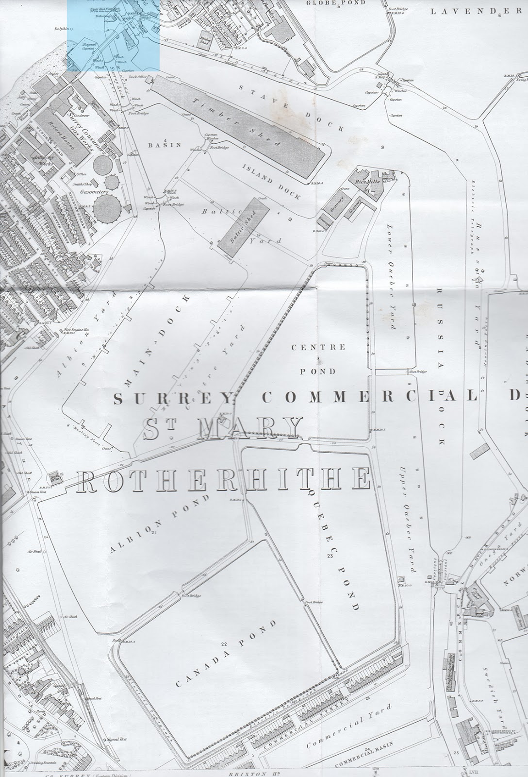
At the same time construction began on Main Dock (later Albion Dock, and not to be confused with Albion Dry Dock) and four timber ponds, which were completed by 1860 and in use by 1862.  The name Albion seems to have been derived from the name of the road that ran along the western edge of Main Dock, Albion Road, which also gave its name to its western yard, and was shown on an 1862 map of the area.  The road is un-named on the 1868 and later Ordnance Survey maps.

The newly excavated Grand Surrey Dock
and Canal System, with the two lock entrances
highlighted at the top of the map.  1868.
With an area of 11.5 acres and  and a depth of 25ft, Main Dock was built mainly for handling timber.  It was flanked by three large yards, Albion Yard to the west and Centre Yard to the East and Baltic Yard to the north.  Baltic Yard sat between Main Dock, Surrey Basin and the Outer Dock.

By 1862 the Grand Surrey Canal Dock and Canal Company had added four timber ponds to their system for the first time:  Timber Ponds 1, 2, 3 and 4 (later named Albion Pond, Centre Pond, Quebec Pond and Canada Pond respectively).  These were designed to compete with similar ponds in the Surrey Commercial Dock system and were intended for the flotation and handling of timber.  The ponds were linked into the rest of the system by a connection between Timber Pond 1 and Main Dock.  

In 1864 the two companies that now operated dock networks on Rotherhithe as independent systems, the Grand Surrey Dock and Canal Company and the Commercial Dock Company amalgamated to become the Surrey Commercial Dock Company, as the result of  a price war between the two that damaged both companies and competition from dock companies north of the river. Linkages between the two systems were made, allowing them to form a single massive network that covered most of Rotherhithe.

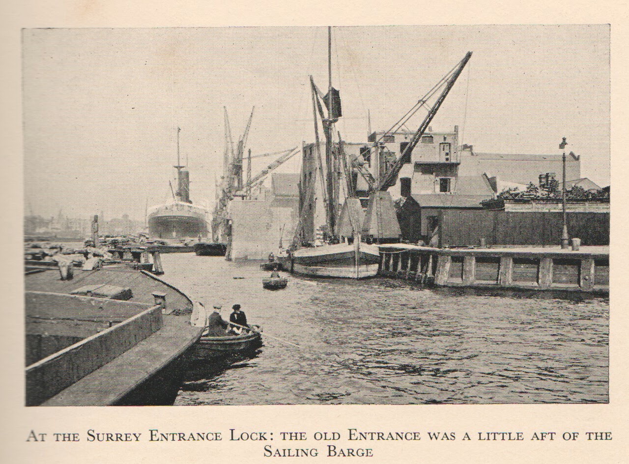
The first lock was sealed off from the dock system in 1888 and was later used as a Thames wharf.  Today its position is marked as an inlet downriver of Pacific Wharf, the modern apartment block next to the Old Salt Quay public house.   

Partial view of the Surrey Entrance Lock from the
Thames, to the right.  From "Lure and Lore of
London's River" by AG Linney, 1932.
During the Second World War, the dock system was severely damaged by bombing.  The northeast side of Albion Dock was severely damaged during the bombing of 9th July 1944 when, just after 2pm, a V1 bomb was dropped on the dock, fell on floating timber and exploded, damaging a nearby brick building, some barges and surrounding property.  On 11th July another V1 bomb was dropped on Centre Yard, injuring six people, at 1126 in the morning.  On the same day, at 1745, another was dropped on Russia Dock, exploding on impact with floating timber and injuring two people. However, the docks were all restored after the war and continued to operate until the closure of the docks in the late 1960s. There's some great black and white footage of a ship arriving in Albion Dock not long before the docks closed in 1970, at:
http://www.bermondsey.biz/apps/videos/videos/show/13071898


Canada Dock completed this part of the dock system, and was built in 1875 by the amalgamated Surrey Commercial Dock Company, and will be discussed in a post that will be published in the next few days.  A new cut was made between Canada Dock and the older part of the system, and the old cut was converted into a dry dock, now known as Albion Dry Dock (about which more can be found here).

Albion Channel
Today's Surrey Water is the complete Surrey Basin, which now supports local bird life.  It was filled in after the closure of the docks but re-excavated by the London Docklands Development Corporation.  The new lock and its gates still survive at the end of Surrey Basin, although it is now no longer operational, connecting Surrey Water to the Thames.  The area that used to be occupied by Albion Dock is marked by Albion Channel and the residential buildings that flank it.  Albion Channel was excavated by the London Dockland Development Corporation in the 1980s to serve as a decorative feature to link Surrey Water (the old Surrey Basin) with Canada Water (the remains of the old Canada Dock).   The spoil from the excavation of the channel went to make Stave Hill. The four timber ponds are covered by a mixture of residential developments and commercial buildings, including Decathlon, Surrey Quays shopping Centre, and Harmsworth Quays.


Thanks as usual to Stuart Rankin's booklets for being such a great resource for local history.  His book, A Short History of the Surrey Commercial Docks can be downloaded as PDF, free of charge, from: http://www.docklandshistorygroup.org.uk/downloads/RankinSurreyDocks.pdf


Friday, February 21, 2014

Former Print Works, Rotherhithe - Meet the Team and Site Tour


This was passed on to me by a PR company acting on behalf of British Land.  British Land will be hosting a ‘Meet the Team’ event and site tour of the Former Print Works on Surrey Quays Road on Saturday 8th March.  They say that they are keen to give as many people as possible the opportunity to see the Print Works and to meet the team before British Land start their public consultation about the future of the site.  

It might be the last opportunity to see the former Print Works. 


Thursday, February 20, 2014

Research paper looking at impact on Victorian London of the Thames embankments now available online

Thanks to the Thames Discovery Project's Twitter update for the information that a new paper by Hanna Steyne is available on the Academia.edu website at http://fb.me/19YPZRVkOStinking Foreshore to Tree Lined Avenue: Investigating the Riverine Lives Impacted by the Construction of the Thames Embankments in Victorian London. It is slightly off-topic for this blog, in that Rotherhithe is not included in the scope of the paper, but for those interested in the development of the London Thames, this is a great read.

Here's the abstract:

Victorian London saw dramatic physical changes along the river Thames. Large enclosed Docks and Thames Embankments were constructed as the city struggled to cope with its ballooning population and prospering shipping industry. Whilst the Thames Embankments have been hailed as engineering triumphs, the fate of those whose livelihood relied on access to the river in central London (such as wharf workers, barge, ferry and lighter men, and others) is unknown. In order to investigate the impact of the Embankment, a methodology has been developed which enables characterisation of a large swathe of urban riverside throughout the mid- to late 19th  century, whilst also ensuring that the stories of individuals and communities are not lost. The approach combines and adapts established methodologies, such as Historic Landscape/Seascape Characterisation and Maritime Cultural Landscapes, to understand the nature and changes in the urban riverside landscape. This methodology forms the back-ground for detailed research on smaller sites, such as a single street, housing block, or industrial site, in order to create ‘Ethnographies of Place’. These small-scale ‘Ethnographies’ have the potential to tell stories about how the social and economic circumstances of individuals and communities changed as a result of the landscape changes associated with the Embankment construction. This paper presents the initial work to establish the methodology and preliminary conclusions based on key sources.


What’s on in Rotherhithe Group Meeting, 24th February 2014 (and minutes for previous meeting)

Another circular sent out for general distribution.  It's the first I've heard of the What's On In Rotherhithe Group.  You live and learn.  I checked their website but it is not currently functional, so I'm not much the wiser, but the website is one of the items on their agenda, so I assume they are looking at getting it fixed.  There's a short introduction on Southwark Council's website.

An interesting point is that there is no information about the heritage collection now housed at Redriff Primary School (presumably the one that used to be at the Lavender Pump House Museum) and whether or not it is accessible to the public.  I would very much like to know the answer to that, because I find it sad that the collection is no longer available to the general public. 

Signage is also another interesting topic.  I was in Russia Dock Woodland the other day and noticed that there is still sign pointing to a "heritage museum" that no longer exists.  Much of it is also all very faded and it would be good to know what is being planned.

February 24th 2014 at 6pm at Sands Film Studios

Agenda

1.    Welcome from Chair & acceptance of any urgent business not on agenda
2.    Apologies
3.    Minutes 21 Oct 2013
4.    Matters arising
5.    Rotherhithe Society Update (Mark Parker; Chair of RS Steering Group)
6.    Rotherhithe Website www.worg.org.uk [not currently functional]
7.    River Piers (RH)
8.    Signage in Rotherhithe including Interpretation Boards & Finger Posts
9.    WORG Publicity including postcards & mugs
10.     Heritage Collection
11.     Albion St update (PEA)
12.     Events including Mayflower 2020
13.     A.O.B
14.     Date of next meeting


Minutes: What’s on in Rotherhithe Group, 6pm October 21st 2013 at Sands Films
Present
Amanda Squires (AS); Michele Page-Jones (MPJ); Olivier Stockman (OS); Pauline Adenwalla (PEA); Robert Hulse (RH); Sue Heath-Downey (SHD);Father Graham (GP);Rebekah Clark (RC)

1 AS welcomed attendees & accepted an agenda item from RC concerning Stave Hill

2 Apologies
  Gary Jones; Colin Smith; Jackie Rose; Tony Evangelou (TE)

3 Minutes 24/06/2013
   Accepted as a true record

4 Matters arising including update on river pier & heritage collection
There has still been no response regarding Clarence Wharf from Simon Hughes. PEA had approached Sellars but they had not been supportive. It was felt that with the 400th anniversary of the sailing of the Mayflower approaching in 2020 that WORG should keep emphasising the need for a river boat pier in Rotherhithe at every opportunity. AS suggested RH contact James Fearnley who is standing as a Rotherhithe Ward councillor at the next council elections to see if he would support the idea of an additional river pier
Action RH to contact James Fearnley

The heritage collection is now at Redriff Primary School but there seems to have been no publicity regarding its access to the public
Action MPJ to write to the Headteacher to enquire about access & also to see if WORG could hold their February meeting there & view the collection

Any other matters arising would be dealt with in the agenda


5 Rotherhithe Website www.worg.org.uk
TE has indicated that he is unable to carry on running the WORG website.AS has received an offer from Simon Wilks via FOSP to help with the website. PEA has also expressed a willingness to update the site.
SHD pointed out that she had been unable to access the site.
Action PEA to investigate & contact Simon to discuss a way forward

6 Reprint of Rotherhithe Map
MPJ had applied under CGS for funding for a reprint of the map and had been successful. WORG had been awarded £1005. WE also received some money from British Land (SQ Shopping Centre); the Mayflower & the Angel. We now have a good supply of maps but do need to always look for funds for future reprints.
Action MPJ to investigate North Southwark Environmental Trust to see if they would support a future reprint
Action Father Graham to ask if the Amicable Society would also be supportive

7 Signage in Rotherhithe including Interpretation Boards & Finger Posts
There was general agreement that the signage in Rotherhithe is poor. Signage is not co-ordinated across the peninsula, often a collection of different signs exist in the same location providing conflicting and unreliable information. Signage is particularly important as often the route is not immediately obvious

Action MPJ to email WORG members to ascertain where finger posts are needed & approach James Oates (LBS Planning) with this information
AS agreed to collate signs & interpretation boards including both pictures & information

Also there is a great need for either revamping existing Interpretation Boards or providing new ones. The Board at Cumberland Gardens was a prime example of a board that needed physically renewing but with the approach of the 400 year anniversary of the sailing of the Mayflower updating also

Action CGS funding to be applied for. See agenda item 9

8 WORG Publicity including banner and postcards
A replacement WORG banner had been bought by AS

Action AS to email round some ideas for Rotherhithe postcards

9 CGS BIDS
Apply for interpretation boards at Surrey Water; Cumberland Gardens; Horse Drinking trough Surrey Quays Rd.
Also outdoor gym at Cumberland Wharf
Renovation of Scotch Derrick see agenda item 14

Action MPJ

10 Albion Street Update
The Christmas Market will take place on 22/23/24 November & the planning is going well
The pop up shop in the empty premises in Albion Street is going ahead but there are no firm details as yet
St Olave’s Square is the subject of a CPO by the council but the owners of the toilets are still appealing against the council’s decision to turn down their planning application
LBS has proposed that the Old Library site be developed by itself as social housing but there is still no decision on the ground floor use  
PEA is putting a number of CGS bids to improve the street scape

11 Rotherhithe Society
AS reported that at the moment there is a steering group chaired by Mark Parker looking at the possibility of a Rotherhithe Society which is envisaged as a voice from the community. It is important that this group is truly representative & also that it does not take over from long established groups. The steering group will be displaying promotional material at the Christmas Market on the WORG stall

12 Events
Christmas Market 22/23/24 November
BRChoral Society Christmas Concert 21st December
Open House September 20 & 21 2014
Open Squares Weekend 14/15 June 2014
   
13 Community Asset Listing
PEA explained that the attempt to list the Albion had failed but there was no reason not to resubmit. She is also trying to list it with English Heritage but does need photos of the interior which are proving difficult to track down


14 Commercial Wharf & Dockhead Crane
MPJ & PEA reported that this crane is in a sorry state of repair & indeed appears to be a health & safety hazard. The whole of Commercial Wharf is very neglected at the moment but it is possibly going to be redeveloped alongside the new Docklands Settlement. It was decided to apply for CGS funding in order to highlight the plight of the Scotch Derrick & keep it in the public eye

Action MPJ to make a CGS bid for refurbishment

15 Additional Agenda Item. Stave Hill Ecology Park
RC said that Stave Hill Ecology Park intends to put forward a bid for section 106 funding and would like the support of the What’s on in Rotherhithe Group.
The Group agreed this and requested RC send a draft letter to MPJ to endorse & forward to LBS

Action RC & MPJ

16 A.O.B.
AS reiterated the fact that the community notice boards were just that & should display items of interest from the whole community & not just those relevant to the key holder.

17 Date of next meeting

Next WORG meeting Monday 24th February 2014 6pm at Sands Films

Although Redriff school are happy for us to view the heritage collection it would not be possible to also hold our meeting there due to time constraints. Therefore a separate visit  will be arranged in the New Year


London i-Tree Eco Project, April 2014


Sent to me for redistribution to anyone interested.  I do wish that not everything had an i- in front of it these days, but it looks like a very good project.


Wednesday, February 19, 2014

Godfrey Edition Old Ordnance Survey Maps of Rotherhithe, 1868, 1864 and 1914


For those interested in the local history of Rotherhithe, three indispensable maps are the 1868, 1894 and 1914 Old Ordnance Survey Maps of Rotherhithe (London Sheet 78).  All three maps show the same part of Rotherhithe peninsula, and for those interested in neighbouring areas, maps of Bermondsey and Deptford North (London Sheet 91) are available Bermondsey and Wapping (London Sheet 77).  

Together the three Rotherhithe sheets, at a scale of approximately 1:4340 (or about 15 inches to a mile), show how the are evolved over this period of time, with all the foreshore wharves and dry docks around the perimeter of the peninsula, the docks in the middle and other commercial building and housing between the two.  Dock offices, industrial works and churches are all marked, and road names are clearly shown.  From one map to the next you can see how things changed, and how various features were sacrificed to make way for dock expansion and the establishment of new facilities, such as St Olave's Infirmary.  Curiously, the detail is slightly different from one year to the next, with the 1968map, for example, being far more helpful for identifying the buildings and businesses that ran around the Thames banks.

On the reverse side of each of the maps are some other useful features.  Brilliantly, they each have a road gazetteer to tell you which businesses or individuals occupied which number of each road.  So on the 1894 map, for example, 19 Rotherhithe Street was Platform Wharf and was  the premises of Groves, Ths. and Sons Wharfingers, whilst 238 Cope Street was occupied by one Eaddy Isaac, lighterman, who lived next door to Oliver John, plumber.  

Also on the reverse side is a short history of Rotherhithe during each of the years, and there is some useful knowledge in these short pieces that doesn't appear in other local histories of the area. 

A schematic on the maps available is also produced, so that if you want to order maps of the surrounding areas as well, you can see very easily which sheet number you will need to acquire. 

If you are interested in the local history of the area, I most sincerely recommend these maps.  Mine are so well used that they look as though they have been mauled.


Tuesday, February 18, 2014

Lovely to see this boat on Greenland Dock today

It was great to see this vessel, masts down and travelling quite fast under engine power, on Greenland Dock today.    I couldn't see her name, and I am useless at identifying anything that has less than three masts and no cargo hold, but she was a really splendidly pretty picture in the sunshine.   If anyone knows her name or anything about her, it would be great if you could let me know.


Monday, February 17, 2014

Nesting pontoons still in a ruined condition in Rotherhithe

Thanks to Steve Cornish (Chair of the Friends of Russia Dock Woodland) for raising the issue of the ruined pontoons on Greenland Dock and Surrey Water, again, with Southwark Council.

The photos on this post were all taken over the weekend by Steve.  As you can see, in spite of promises made last year in response to the ruinous state of the pontoons, there has been no work to build more new nesting pontoons or even try to salvage and maintain what we had only two seasons ago. Steve has mailed the Head of Environment and the officers in charge of the peninsula's waterways but has as yet received no reply. Local people have nesting material ready to go, but the pontoons are either half sunken or pressed up against the dock wall where they are unsafe.

As you can see, the waterfowl have already started building and in some cases they have started laying because of the mild winter.  Those of us who monitored the situation last year will remember how nests were submerged due to semi-sunken pontoons, leading to the loss of both moorhen and swan eggs. See my post last year "Plight of nesting swans and coots in Greenland Dock" to see how bad things were for the nesting water birds.  The situation is obviously unacceptable and we are waiting on Southwark Council to explain how they intend to respond to the situation.

Apparently, the Trust For Urban Ecology at Stave Hill Ecological Park used to be paid to upkeep, renew or maintain the pontoons, but after 2012 but that money was withdrawn, and Southwark Council has failed to act to ensure that the necessary work has been carried out by another party.


Sunday, February 16, 2014

Russia Dock Woodland after the gales


Today was such an incongruously divine day, in the overall context of the storms and gales that we have come to expect recently, that I couldn't wait to get out and breathe in some fresh air and enjoy the sunshine.  

Sadly, the gales had taken their toll and there were several fallen trees and a lot of fallen branches and twigs.  The one that has fallen across the main access from Waterman's Walk to Globe Pond is causing the most obvious difficulties (the photograph at top left), with families lifting bicyles across it in order to use the path, but other obstructions are less troublesome.  Judging by the number of official looking people surveying them, they are clearly being dealt with and everything else looked very well manicured, and it all sparkled in the sun.  

There were snowdrops and crocuses, even some early violets and lots of new shoots. Lovely. The yellow flag water irises are going to be amazing this year, particularly as all the water channels are absolutely full at the moment.  And the moss is running riot, forming bright lime-green carpets.  The blackbirds were busy excavating the leaf fall, and a woodpecker was giving a tree some serious grief behind the Downtown pond.  There were lots of people out enjoying the day, and it was good to see everything coming back to life after the battering it has taken over the last weeks.  In spite of the dire weather recently, today did hold the promise of Spring.  It was just so marvelous to get out of the house!

Displaying my usual lack of basic common sense I went out in brand new pure-white trainers, and returned with a distinctly sad pair of mud-black trainers.   It was distinctly sludgy underfoot! 


Friday, February 14, 2014

The people in the classic photograph of the 1928 flood in Rotherhithe

Yesterday I posted photographs of the 1928 flood in Rotherhithe.  One of them, shown here, is a classic, reproduced frequently in the media and on the web.  Today I dropped into the Moby Dick pub on my way back from the hellhole otherwise known as Surrey Quays shopping centre.  I was fortunate enough to run into a good friend who was with two mates, Steve and Fred, who I didn't know.  Steve and Fred grew up around here and told me some brilliant stories about the docks.  I mentioned the flood and the photographs, and asked if they had seen them because they capture a moment of local history so evocatively.  Steve showed me a photo on his phone and said, with a big smile, - you mean this photo?   And it was the photo on this post.

The child being lowered was Steve's father Peter Charles Awcock, and the woman lowering him was Peter's mother Ellen.   It's good to know that Steve's dad survived the handover process, which looks distinctly perilous!  One of the women looking out of another window was Peter's Aunt Lidya.  On the raft were two casual dock workers, Mr Tull and Mr Evans.  The photograph was taken by one of the Tull family, "Nipper" Tull, who Fred says were a big family in Rotherhithe up until the closure of the docks.  It is so nice to be able to put some names to the faces! The houses were the Mestaers Buildings, which is where the Amos Estate is now located, the old houses having been knocked down in the 30s or 40s.   

I shall be torturing Steve and Fred for many more stories about what the area was like when they were growing up here.